


View north up the Timaru District coastline showing an interruption by the Timaru basalt formation. It forms the first hill south of the Canterbury Plains where Timaru's Hilton Highway ends (named after Timaru's first woman Mayor of Timaru City 1959-62). Photography courtesy of Geoff Cloake 2012.
About 2–2.5 million years ago, lava erupted from the Wapouri / Mount Horrible area inland of Timaru and flowed downslope towards what is now the coast. This lava formed the Timaru Basalt, regarded as the South Island’s youngest volcanic episode.
Unlike the classic cone-shaped volcano people often imagine, this eruption produced a broad lava field. It appears to have been a single eruptive event, after which volcanic activity ceased. Over time, the lava cooled into basalt, and later erosion helped expose and shape the rock, which in some areas became the rocky reefs, headlands and coastal platforms that became part of Timaru’s shoreline.
The sea was not fixed in one place. Over long periods, the coastline advanced, retreated, eroded and reshaped the basalt. Today, we can still see this volcanic story in places such as Dashing Rocks, where dark basalt is capped by pale loess cliffs. The basalt “apron” at the foot of the cliffs is part of the ancient lava flow, now shaped by waves, weather and time.
This geology helped create Timaru’s natural harbour. The volcanic reefs gave some shelter to the early shoreline, while the surrounding loess cliffs, wetlands, gravel beaches and streams shaped the coast long before the modern port and Caroline Bay were created.
Caroline Bay itself has changed dramatically. Two hundred years ago, the sea met a very different edge: rocky shoreline, loess cliffs, wetlands, coarse gravel beaches and streams. Pohatu-koko Stream once ran from the area near the bottom of Wai-iti Road towards the sea. Today it is largely hidden underground, piped beneath the modern playground and out to the coast.

CPlay's "Floor Is Lava" obstical course. For some friendly competition two people could race each other by starting at the ninja wall going down one side of the course and running back up the other side to race up the catch the flag 4m high pole. For an easier challenge you could trying moving up and down the course by only stepping on rock to avoid the lava. - South Canterbury Drone Photography
The sandy beach at Caroline Bay is an area of reclaimed land, shaped since the 1880s by currents and the city’s changing coastline.
The construction of the Timaru Harbour breakwaters from the late nineteenth century changed the movement of sediment along the coast. The harbour works interrupted the natural drift of material northwards, and sand began to accumulate inside the shelter of the bay. Over time, this helped form the sandy Caroline Bay beach we know today. At the same time, changes to the coastline contributed to erosion further north, including around Waimataitai Lagoon, now Ashbury Park, and Waitarakao / Washdyke Lagoon. Learn more here: Waitarakao Washdyke Lagoon.
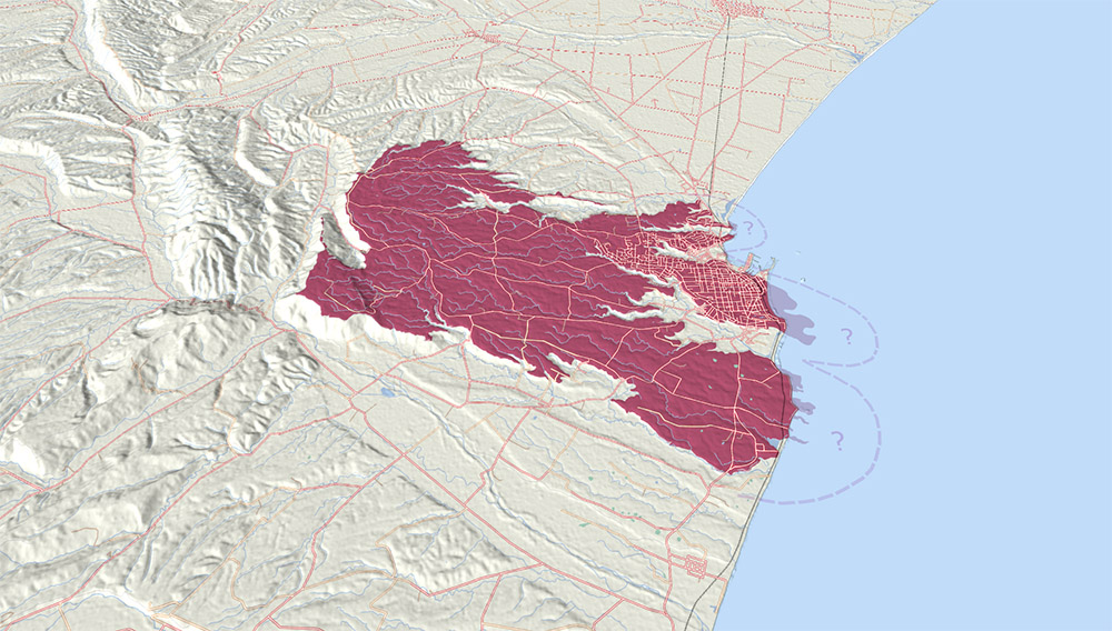
Lava once flowed from somewhere west of Claremont (Wapouri / Mount Horrible) down a gentle sloping plain. The sea was probably nowhere near the erupting lava but has advanced occasionally, eroding the basalt and helping to form the current coastline. Diagram courtesy of Geoff Cloake.
Timaru’s basalt was also useful. It became known locally as “bluestone” and was quarried for buildings, bridges, harbour works and erosion protection. Basalt blocks can still be seen in many of Timaru’s older buildings and structures. Rock quarried from areas including what is now Centennial Park helped build and protect the Port of Timaru. Some of the stone was moved by tramway from the quarries to the harbour, where it was used in the construction of breakwaters and coastal defences.
The land now known as Centennial Park has its own quarrying story. The Timaru Harbour Board once owned much of this area and worked several quarries there from the late nineteenth century. Rock was carried from the reserve by tramway to the port. The last of these lines was removed in 1959. The park later became a public reserve, formally opened as Scenic Reserve in 1938, and renamed Centennial Park by 1940 to mark the centenary of the signing of Te Tiriti o Waitangi / the Treaty of Waitangi.
The cliffs above Timaru’s coast tell another part of the story. The pale material sitting above the basalt is loess — fine wind-blown silt carried from glacial riverbeds and plains during colder, windier periods. These loess layers built up over thousands of years and preserve evidence of past climates. At Dashing Rocks, layers of loess and buried soils sit above the eroded surface of the Timaru Basalt, creating one of the district’s most important geological records.
John Hardcastle, an amateur geologist who worked for the Timaru Herald, studied these loess cliffs carefully. His observations helped show the relationship between loess layers and past climate change. His work was later recognised internationally, and in 1991 scientists meeting in Beijing discussed his contribution to the study of loess and climate history.
This is why Timaru’s coastline is more than a scenic edge. It is a layered record of lava, sea, wind, rivers, wetlands, quarrying, harbour engineering and human settlement. The same ancient basalt that helped shape the reefs and headlands also helped build the port, protect the coast, and supply stone for the town.

The loess (looks like clay) has layered over time. And gives us a record of changes in our local climate.
ABOVE LEFT: Distribution of Late Pleistocene Loess. You can see that Timaru has a "very thick" layer. Loess Section exposed at Dashing Rocks, Timaru.
ABOVE RIGHT: Four loess layers overlie the eroded surface of the Timaru Basalt. - Nature and distribution of loess in Canterbury, New Zealand This is sediment that has been blown here, is dust from glacial carving periods.

Looking in a northerly direction down from a terrace towards Caroline Bay. The beach and a large low building are in the middle distance. The Southern Alps are in the background.- Barton, Cranleigh Harper, 1890-1975 A-227-335/349: Barton, Cranleigh Harper 1890-1975 :[Scenes from Geraldine to Oamaru] [ca 1950?]

View of township looking across water to foreshore with Southern Alps in background. Pencil and watercolour (A-157-018) by Arthur Lagden Haylock (1860-1948) c1878. Arthur probably created this when he worked in Timaru as a cadet in the Lands Office. Courtesy of Alexander Turnbull Library, Wellington, New Zealand.

Basalt was quarried from lava that flowed from Wapouri / Mount Horrible.It was positioned along the Caroline Bay and Benvenue Cliffs to reduce the erosion.

The basalt at Dashing Rocks flowed here from Wapouri / Mount Horrible.

The CPlay team were inspired by the local geology to create an obstical course themed on lava. Features 4m catch the flag, 3m ninja wall, double sided triple rockwall, 3m ninga finger wall, horizontal totem pole, and an up and over climbing net. A fitness area has also been designed to help people build their fitness, co-ordination and strength.
-
Physical development: This obstacle course has been designed to challenge kids and adults physically, requiring them to run, jump, crawl, climb, balance, and perform other movements that improve physical fitness, coordination, and motor skills.
-
Mental development: People can problem-solve, strategize, and use critical thinking skills to navigate through the course. This can help develop mental resilience and adaptability.
-
Emotional development: Overcoming obstacles can give people a sense of accomplishment, which can improve self-esteem and confidence. It can also help develop resilience and the ability to manage stress and anxiety.
-
Social development: Obstacle courses can be done individually or as a team, encouraging individuals to work together, communicate effectively, and build social skills. There are two sides that are the same, so people can race each other, cross over and run back down the course. They can race up the flag pole and catch the flag to win.
At CPlay, the “Floor Is Lava” obstacle course was inspired by this local geology. It turns a deep-time story into play: lava flows, rocks, climbing, balancing, racing and movement. Children may not know they are following a 2-million-year-old geological story, but the landscape beneath their feet is part of the game.
Timaru’s hills, reefs and cliffs are not just background scenery. They are the foundations of the place.

Basalt (cooled lava) being quarried at Centenial Park. - Harbour Board Quarry, Timaru, New Zealand, by Muir & Moodie. Te Papa (C.014398)

The rock being transported to the Port of Timaru. Here you can see wagons that were operated by the Timaru Harbour Board's Otupua Tramway which ran from the Eastern Extension to the quarries in what is today's Scnenic Reserve they date back to 1900. The Tramway closed in 1958. The "six wheeled tipping wagons" are now on display at the Pleasant Point Railway Museum.