

CPlay-Tuna-Resource-250217.pdf
The Story of Tuna and the Lost Lagoon

Imagine This…
Picture being a young tuna, swimming home from near Tonga to find your lagoon gone. How would you feel? What would you do? Can you find your mother and some tuna friends?

Progress on the tuna eel mound with Playground Center equipment and design by Creo. The rubber surfacing was installed by Numat Rec. - Jack Rushton

Eels (Tuna) are seen by Māori as taonga (treasures) and ancestors, reminding us of our connection to nature and the importance of caring for it.
“Tuna" is the general Māori name for eels. There are three types of eels in Aotearoa New Zealand (NZ): longfin, shortfin, and Australian longfin.
Eels are often called "living fossils" because their body structure has remained largely unchanged for millions of years. We still don’t fully understand their evolution.

Tuna is a generic Māori word for freshwater eels. Māori have over 100 names for eels.
I LIVE: lakes and rivers connected to the sea.
I EAT: Small insects larvae, snails, midges and crustaceans. As our mouths get bigger, we can eat kōura (freshwater crayfish), fish, small birds and rats. When scared I bite!
Did you know: I’m the largest fish in Aotearoa freshwaters
There are three tuna species in NZ: The longfin eel, known as tuna, are unique to NZ, and are one of the largest eels in the world.
LONGFIN EEL
(Anguilla dieffenbachii) Max size: 2m, 25kg
SHORTFIN EEL
(Anguilla australis) Max size: 1.1 metre, 3kg
AUSTRALIAN LONGFIN EEL
(Anguilla reinhardtii), Max size: 2 metres, 21kg

At the end of their lives, eels leave NZ to spawn near Tonga, Samoa, and Fiji. Their fertilised eggs grow into larvae, which drift thousands of kilometers on ocean currents, eventually becoming 6–8 cm glass eels. Near the shore, these glass eels grow into 10–15 cm elvers and move into streams, wetlands, and rivers, often returning to the very places where their mothers lived. Eels can grow up to 1-2 meters long and live for over 100 years! They then return to the sea as migrant Tuna Heke to begin the life cycle again.
My super power is:
- I can swim 1000s km in the sea or fresh water.
- Near the end of my life, I swim from NZ to the deep trenches near Tonga.
- This is where I release eggs/sperm to spawn.
- Over 10 months, my tiny larvae follow the ocean currents back to NZ.
- They develop into transparent glass eels, and swim to rivers.
- They turn greyish-brown and become elvers, to grow into strong adults in fresh water (rivers, lakes, wetlands). Then the swim back to sea and repeat our life cycle.
I help the eco system as a top predator and food source in the marine food chain and help balance the ocean environment.
I am a Taonga species central to the identity and well being of many Māori and are a significant mahinga kai (food).
Treasured & Mysterious
Eels (Tuna) are seen by Māori as taonga (treasures) and ancestors, reminding us of our connection to nature and the importance of caring for it. “Tuna" is the general Māori name for eels. There are three types of eels in Aotearoa New Zealand (NZ): longfin, shortfin, and Australian longfin. Eels are often called "living fossils" because their body structure has remained largely unchanged for millions of years. We still don’t fully understand their evolution.
Incredible Adaptations
- Eels are born without a gender. They grow faster in areas with fewer eels and become females, while those in crowded, competitive environments grow slower and become males.
- Eels are carnivores and use their teeth to eat insects, worms, fish, small birds, and even mice.
- Although they rarely bite humans,if they do, it can result in a painful graze.
- Before starting their long journey to the ocean to spawn, eels undergo dramatic body changes. Their heads flatten, and their eyes enlarge.
Mysterious Migration
- Eels don’t rely on sight; instead, they follow invisible paths using environmental cues such as the Earth's magnetic field, temperature, and salinity.
- During their journey, they cannot feed and rely solely on stored body fat for energy.
- No one has ever seen eels reproduce in the wild. Scientists believe instinct guides longfin eels to the Tongan Trench and shortfin eels to waters near Samoa and Fiji.
- They pass through the deep Kermadec and Tongan Trenches, where the Pacific Plate is sliding under the Australian Plate, creating the ideal deep-sea conditions for reproduction.
INCREDIBLE MIGRATION
Eels swim for 3–6 months from New Zealand to the deep ocean trenches west of Tonga to spawn—an epic journey of 5,000–6,000 km!
Fascinating Cycle
At the end of their lives, eels leave NZ to spawn near Tonga, Samoa, and Fiji.
Their fertilised eggs grow into larvae, which drift thousands of kilometres on ocean currents, eventually becoming 6–8 cm glass eels.
Near the shore, these glass eels grow into 10–15 cm elvers and move into streams, wetlands, and rivers, often returning to the very places where their mothers lived.
Eels can grow up to 1-2 metres long and live for over 100 years!
They then return to the sea as migrant Tuna Heke to begin the life cycle again.
Longfin eels are unique to NZ, and are among the largest eel species in the world!
Lost Habitat
Imagine arriving at your mother’s home after such a long journey, only to find the lagoon has disappeared and the creek is polluted.
Waimātaitai was once a 50-acre lagoon (hāpua) and eel weir (e rauiri) where Ashbury Park and the supermarket are today.
"Waimātaitai "Waimataitai"
Waimātaitai was a hāpua (lagoon) situated near the Tīmaru foreshore, renowned as an important source of mahinga kai. In 1880 Hoani Kāhu from Arowhenua described Waimātaitai as “e rauiri” (an eel weir) where tuna (eel) and inaka (whitebait) were gathered. This saltwater lagoon was eventually lost in 1933 due to changes in sediment drift caused by the creation of the Port of Tīmaru. - https://kahurumanu.co.nz/atlas"
It was drained in 1933, leading to the loss of critical eel habitat. All that remains is a small creek, now connected to the sea by a 1.35 km stormwater drain.

Miscellaneous Plans - Borough of Timaru, South Canterbury. T.N. Brodrick, Chief Surveyor Canterbury. Held by: Archives New Zealand/Te Rua Mahara o te Kāwanatanga, Christchurch Regional Office - Archway Record Code: R25538727
The creek once flowed into a 50 acre lagoon and swamp, and was a significant mahika kai site for Māori. A 1.3km storm water drain was installed in the 1930s to divert the creek underground, and the area was drained. Ashbury Park and the supermarket sit on this reclaimed area.
Can you see Whitebait/Inanga, Adult Whitebait/Kokopu and Eels/Tuna in the creek? The Waimātaitai Creek has been poorly treated since European settlement, and used as a rubbish dump and became overgrown with weeds. In 1996, Timaru TOP 10 began removing truckloads of rubbish from the section of the creek within the Park. Flooding still brings up more rubbish from the riverbed, so regular clean-ups are needed. Willows, sycamore, blackberry, and elm, were removed and over 1,000 native trees have been planted, with more added regularly.
The first plants were Flax (Harakeke) and Carex Grasses, followed by Lemonwood (Tarata), Lacebark (Hoheria), Five Finger (Patē), Matipo, Wineberry (Makomako), Broadleaf (Kapuka), Cabbage Tree (Tī Kōuka), and Kōwhai. It is hoped these plants will attract more native birds. Currently, you can see Fantails/Pīwakawaka, Silvereyes/Pihipihi, Grey Warbler/Riroriro, and Bellbirds/Tītipa in the area. A trapping programme is also in place to control mice and rats.

Borough of Timaru South Canterbury-1948-nlnzimage-Sourced from LINZ - Crown Copyright reserved
How you can help
- Feed eels only meat, no bones, eggs, or vegetables.
- Stay out of the water and don’t throw stones.
- Cover rubbish bins to prevent attracting pests and to stop rubbish blowing into the creek.
- Improve water quality, ensure only rainwater enters stormwater drains. Wash your car on grass and use biodegradable detergents.

Prepared by Geoff Cloake, Roselyn Fauth and Niwa 2024.
Zealandia Te Riu-a-Māui
Is a mostly submerged continent in the southwest Pacific, with 94% underwater.
Its visible land includes New Zealand and New Caledonia.
To the north are the Kermadec and Tongan Trenches, where the Pacific Plate subducts beneath the Australian Plate, forming deep ocean trenches. Nearby Tonga and Fiji
are volcanic islands on the Pacific Plate.

J. S. Browning, (1831 – 1909), Timaru Looking North West, 1860, file copy print, Hocken Collections, Uare Taoka o Hākena, University of Otago.

Timaru Harbour, Province of Canterbury : general chart of Timaru and adjoining coast by Sir John Coode showing works recommended by Sir John Coode, August 1875. (from Patiti Point to Washdyke Lagoon). The proposed works are shown by red colour. timdc.pastperfectonline.com/DCEC5B88-61FE-4949-80EC-525377755260

One of the ways you can investigate is visiting 9th Century Black Maps - Check out that huge lagoon and wetland that used to be where Washdyke industrial area is today... you can also see the Waimataitai wetland that used to be at Ashbury Park and the changes at Otipua Wetlands too! https://www.arcgis.com/apps/webappviewer/index.html?id=bec5eceea7514735b73bbe9e8082371f
Here you can see the Timaru Coastline, comparing the digitized survey maps (that were created 1848 - c.1870s) to 2022. The surveys were carried out for the legal purchase and sale of land parcels, initially under the administration of the Canterbury Association, which was founded in London 27 March 1848 in order to establish a Church of England settlement in New Zealand. The historic survey maps are a crucial source of information showing the Ngāi Tahu relationship with the landscape of Te Waipounamu. The Black Maps are fascinating objects that help bring to life the story of pākehā exploration and the development of Canterbury. https://apps.canterburymaps.govt.nz/BlackMaps
This gives an insight into traditional areas of mahinga kai (sites of significance to Māori for food gathering) such as wetlands, lagoons, and estuaries before they were modified. - https://mapviewer.canterburymaps.govt.nz/?webmap=0db87348adef4595a91994a3dc85cefe&extent=1457673.4475%2C5078749.6304%2C1476018.3343%2C5087320.1322%2C2193

Above you can see the stream that runs past Timaru Top 10 Holiday Park. This runs under Ashbury Park to sea. The park used to be a large tuna weir. "Waimātaitai was a hāpua (lagoon) renowned as an important source of mahinga kai. In 1880 Hoani Kāhu from Arowhenua described Waimātaitai as “e rauiri” (an eel weir) where tuna (eel) and inaka (whitebait) were gathered. This saltwater lagoon was eventually lost in 1933 due to changes in sediment drift caused by the creation of the Port of Tīmaru." - kahurumanu.co.nz/atlas

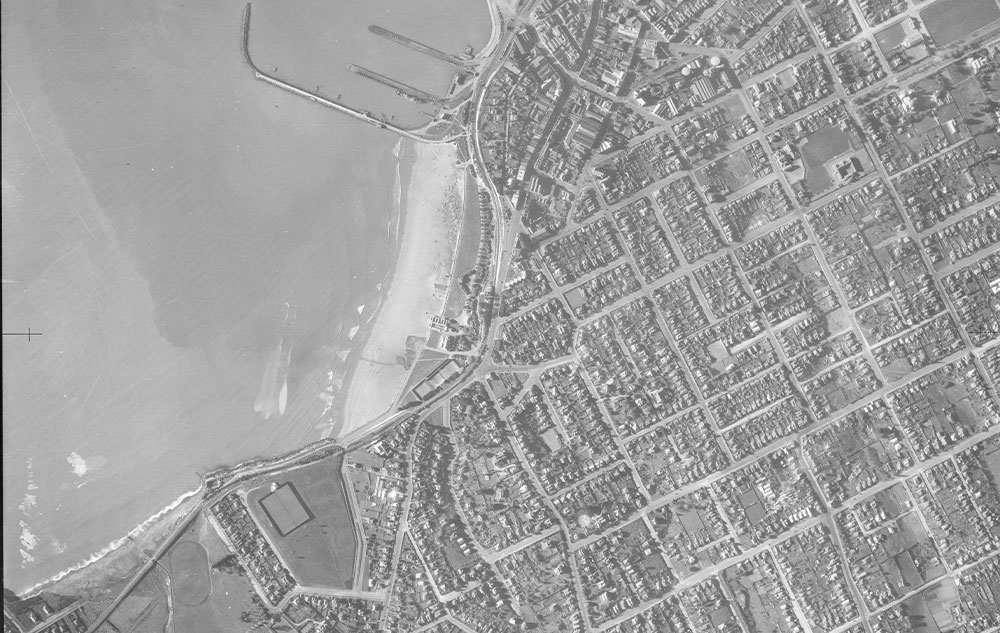
What was once a lagoon, is now Ashbury Park. Aerial view of Timaru, showing Caroline Bay, harbour and town between 1920 and 1939. - Auckland Libraries Heritage Collections FDM-0690-G

Postcard with a black and white image of a view across water that has a fence running through it towards buildings on a hill and mountains in the background titled "Salt Water Creek Lagoon, Timaru N.Z". Gold Medal series. Addressed to C.M. Deek Esq and postmarked. Canterbury Museum. Other id 6856. Accession number 2004.39.2144


This 1874 sketch is from Benvenue Cliffs looking to Dashing rocks. You can see the spit that used to be here and the lagoon on the left. Eliot was here taking measurements to draw the Harbour construction plans. After the breakwater was started in 1878, it was noticed that the shingle bank was being eroded. In the early 1800s, basalt rock was brought in to protect the bank and the rail way behind it. By the 1820s the lagoon was under threat, it was filled in and by 1935 the Waimataitai Lagoon was gone.
- Eliot, Whately. 1874, Near Timaru, N.Z., Sept. 23, 1874 , viewed 27 April 2023 http://nla.gov.au/nla.obj-138582026

Tuna / eels in the steam that runs beside the holiday park. This stream connects to a underground drain under Ashbury Park, Waimataitai Beach. Photo Supplied by Timaru Top 10 Holiday Park.

Niwa has published an climate report "Understanding Taonga Freshwater Fish Populations in Aotearoa-New Zealand" here: https://waimaori.maori.nz/wp-content/uploads/2019/05/Understanding-Taonga-Freshwater-Fish-Populations-in-Aotearoa-New-Zealand.pdf
Coastal Changes - Ashbury Park / Waimātaitai

The Waimataitai Lagoon, once situated seaside of Ashbury Park and fed by Waimataitai Creek, was a 50-acre lagoon crossed by a railway trestle and known as Woollcombe's Lagoon. The creation of the Port of Timaru altered sediment drift, causing the lagoon's enclosing barrier to erode in the 1930s, leading to the lagoon's loss by 1933. The Waimataitai Estate, covering areas including modern streets like Pringle St. and Belfield St., had boundaries marked by the sea, Evans Street, and Taitarakihi Creek. The estate included properties, gardens, and farmlets owned by Herbert Belfield and other historical figures like Thomas Pringle. The lagoon area and nearby properties were significantly impacted by floods and erosion, leading to changes in land use and ownership over time. Historical records detail the involvement of Belfield and Woollcombe in local development and community activities.
Waimātaitai "Waimataitai" was a hāpua (lagoon) situated near the Tīmaru foreshore, renowned as an important source of mahinga kai. In 1880 Hoani Kāhu from Arowhenua described Waimātaitai as “e rauiri” (an eel weir) where tuna (eel) and inaka (whitebait) were gathered. This saltwater lagoon was eventually lost in 1933 due to changes in sediment drift caused by the creation of the Port of Tīmaru. - https://kahurumanu.co.nz/atlas
View from above, the Waimātaitai lagoon has drained and been reclaimed as Ashbury Park with an athletics track. Sand is accumulating in Caroline Bay and tennis courts, grass prominade and caretakers house are established.
Tuna or freshwater eels are a very significant, widely-valued, heavily-exploited, culturally iconic mahinga kai resource. Although there are many stories and legends of tuna spawning in freshwater, what is certain is that all freshwater eels spawn at sea. Adult freshwater (living in streams, lakes, wetlands) can live up to 100 year old. They feed on insects, snails, fish, and even birds. Female tuna can reach 2 meters long. They leave their home and migrate thousands of kilometres from the fresh water to the sea water into the Pacific Ocean to release eggs and sperm in a process called spawning. Their eggs hatch far in the South Pacific Ocean near Tonga. They are very small and can only be seen using a microscope. The fertilised eggs then develop into larvae called leptocephali, which travel back to New Zealand drifting via ocean currents over 9-12 months and eventually arrive in New Zealand. Eels then enter our rivers as small juveniles that are known as glass eels. They are about 60-75 mm long. After several weeks in the fresh water the darken an become known as an elver. They migrate upstream during the summer. They are able to climb obstacles until they get to 120mm length. - niwa.co.nz/life-cycle

ABOVE: Map of the pacific ocean and "ring of fire" showing the edge of the techtonic plate that forms the Alpine Fault line in New Zealand, and the Kermadec and Tonga Trench's. The Kermadec Trench is one of Earth's deepest oceanic trenches. Every year, a proportion of eels mature and migrate to sea to spawn. Downstream migrations normally occur at night during the dark phases of the moon, and are often triggered by high rainfall and floods. National Geographic

Location of archival pop-up tags ascent locations on four longfin eels tagged and released from south of Christchurch. The tags were programmed to release from each eel at a different time. Once the tags came up to the ocean surface they sent all of the data they had been collecting via satellite to NIWA scientists eagerly awaiting the results. Credit: Don Jellyman
'Ka hāhā te tuna ki te roto; ka hāhā te reo ke te kaika; ka hāhā te takata ki te whenua' - If there is no tuna (eels) in the lake; there will be no language or culture resounding in the home; and no people on the land; however, if there are tuna in the lake; language and culture will thrive; and the people will live proudly on the land - Nā Charisma Rangipuna i tuhi
They are legendary climbers and have penetrated well inland in most river systems, even those with natural barriers.


Elver eels wiggling their way into Lake Opuha via the Elver Bypass 2023. Photo's Supplied by Opuha Water Limited (OWL)
Elver bypasses on the Opuha Dam infrastructure ensure tuna/eels can continue their migration up the Opuha River into Lake Opuha. Here you can see little Elver (juvenile tuna/eels) at the Opuha Dam. They wiggle their way up the elver bypass, a special pipe which runs up the side of the 50m high dam from the Opuha River, and drops down the other side into the lake.
Elvers migrate upstream, typically between late November and early March, when temperatures reach about 16°C. They are able to climb damp vertical surfaces until they are about 12 cm long, at which size they are too heavy to stick using surface tension.
Most high dams in New Zealand are now equipped with bypasses, eel ladders and/or have trap and transfer operations. What is reasonably uncommon in NZ is monitoring to understand the effectiveness of the bypasses. To help fill this gap in knowledge, Opuha Water Ltd (OWL) are currently doing some small modifications to the elver bypass boxes to enable their team to temporarily catch and count how many elver are going into the lake.
OWL doesn't have a mechanism to provide for adult tuna to migrate downstream but are actively pursuing opportunities to establish a trap and transfer programme, whereby adult eel are netted and transferred downstream below the dam where they can then migrate out to sea.

Above: The Lake Opuha Dam was built in the late 1990's. Lake Opuha is a 700 hectare man-made lake, built as an irrigation reservoir as an infrastructure project undertaken by the community of South Canterbury. The Opuha Dam, (where the North and South Opuha Rivers meet near Fairlie), also generates electricity before water flows on to meet the Opihi River further down stream.
As well as the increased value of the farms and the farming activities, the reliable irrigation has provides growth for various vegetable processing exporting operations in Washdyke and has supported the growth of the massive dairy processing facility at nearby Clandeboye.
The 7MW power station contributes to the local electricity network and the revenue from the electricity sales accounts for approximately half of the company’s income.


References:
- Te Taura Whiri i te Reo Maori (1989) Ngai Tahu 1880. H.K. Taiaroa. (Unpublished typescript) [English translation of two original notebooks in Te Reo Maori of place names related to mahinga kai compiled by H.K. Taiaroa in 1880 from information provided by Ngai Tahu informants]. Ngai Tahu Archive. Collection 140. Item D301, Box 102, D. Wai-27. Wai-27 Doc – R30 – Book “Ngai Tahu 1880.” Macmillan Brown Library Archives Collection. P203:175.
- Kāhu, Hoani cited in Beattie, J.H. (1945) Maori place names of Canterbury: including one thousand hitherto unpublished names collected from Maori sources. Dunedin, N.Z. : Printed by the Otago Daily Times and Witness Newspapers. P68 & 82.
- Beattie, J.H. (1945) Maori place names of Canterbury: including one thousand hitherto unpublished names collected from Maori sources. Dunedin, N.Z. : Printed by the Otago Daily Times and Witness Newspapers. P84 & 113.
- Taylor, W.A. (1952) Lore and history of the South Island Māori. Christchurch, N.Z.: Bascands. P94.
- Kāhu, Hoani cited in Beattie, J.H. (date unknown). Kahu, John. Maori Notebook, 1880. Unpublished. MS-582/F/11 in, in Beattie, James Herries: Papers (1848-1970) ARC-0162, Hocken Collections, Uare Taoka o Hakena, University of Otago. P16 & 21.