
By Roselyn Fauth
The Caroline Bay Playground in Timaru, now includes the name 'Pohatu-Koko' in its surfacing, a powerful tribute to the lost Māori place name of the stream that runs beneath the playground. This meaningful endeavor was realized through the efforts of CPlay volunteers, supported by Te Rūnanga o Arowhenua, the Timaru District Council, and in collaboration with professional playground designers and suppliers, the Playground Centre and Creo.
In March 2021, Te Rūnanga o Arowhenua bestowed the privilege of including the name 'Pohatu-Koko' in the playground, a fitting acknowledgment of the stream's original Māori name. What was once 'Whale's Creek' has now been channeled underground through stormwater pipes beneath the playground, reemerging at Caroline Bay.

LEFT An early map of Timaru in 1860. RIGHT zoomed in area showing the labeled area "Pohatu Koko" next to the "old whaling station". This is where the traffic lights are at the end of Wai-iti Rd, and Evans St. The stream running through the area can be seen above. This stream is now piped under the viaduct at the bottom of Wai-iti Rd, under the playground and out sea at the Benvenue end of the boardwalk. Courtesy of the National Library. Archives New Zealand/Te Rua Mahara o te Kāwanatanga. Christchurch Office. Archives reference: CH1031, BM 245 pt 2, R22668176
CPlay volunteer Roselyn Fauth emphasized the significance of integrating 'Pohatu-Koko': "Integrating the Maori name 'Pohatu-Koko' into the new playground is a way to honor our indigenous heritage, acknowledge their connection to the land, and celebrate the cultural richness that defines New Zealand. It's about more than just a name; it's a symbol of respect, cultural preservation, and unity, which are an important to our identity and history."
The historical context of 'Pohatu-Koko' includes the presence of early European whalers, some of the first European explorers in the South Canterbury region. European exploration of New Zealand dates back to the 17th century when Dutch explorer Abel Tasman documented finding the land in 1642. European whalers initially sought fur seals, known for their valuable pelts, in the coastal regions around Timaru in the late 18th century.

The rustic bridge Caroline Bay over "Whales Creek" Timaru circa 1915 pictures several children on and around the bridge, part of the walkway leading to the Caretaker's Cottage and Tea Rooms on the Bay (in the background). - South Canterbury Museum 2015/150.02
European contact with Māori communities was regional and mutually beneficial, with Māori sharing knowledge, resources, and even crew members for whaling vessels. The Weller Brothers established a whaling station in Timaru in 1839 near 'Pohatu-Koko,' also known as 'Whaler's Creek,' which appeared on early maps. The stream used to run across Caroline Bay, but was later piped underground to the sea.
The name 'Caroline Bay' itself has historical roots, possibly named after the ship "Caroline," which anchored following the Weller Brothers' whaling station establishment. This ship transported whale oil and whalebone.
 LEFT A try pot used at the Weller Bros Whaling Station near this place 1839-1840. The Wellers’ workers caught whales and rendered the blubber down into oil in try pots for two seasons Members of the whaling gang were the first white men to live even temporarily in South Canterbury. RIGHT Looking up towards the viaduct near the Evans St and Wai-iti Rd intersection where the stream runs underground. Photograph courtesy of Roselyn Fauth
The whaling industry in Timaru was relatively short-lived, with the whaling station was abandoned before the third season. Today, we reflect on this historical context as 'Pohatu-Koko' reemerges, preserving Māori heritage and emphasizing the interconnectedness of Māori and European history in New Zealand.
'Pohatu-Koko' at Caroline Bay serves as a reminder of the Māori and European whalers who once called this area home, highlighting the rich cultural tapestry that defines modern New Zealand and the enduring legacy of history.
History
- 17th Century: European exploration and contact with New Zealand began. Dutch explorer Abel Tasman is recognized as the first European to "discover" New Zealand in 1642.
- 1830s: French settlers established a colony at Akaroa in the South Island of New Zealand.
- Late 18th Century: Sealers were among the first Europeans to visit the coastal regions around Timaru, attracted by fur seals.
- Early 19th Century: European whalers, including Dutch, French, Russian, German, Spanish, Portuguese, and British, began arriving in New Zealand.
- 1839: The Weller Brothers established a whaling station at what is now the corner of Evans St and Wai-iti Rd in Timaru, led by Samuel Williams.
- 1839: The region featured undulating downs, lagoons, clay loess cliffs, and cabbage trees, making it an ideal location for whaling activities.
- 1839: Whalers set up camp near Pohatu-Koko stream, which they nicknamed "Whaler's Creek."
- 1839: Some suggest that Caroline Bay was named after the ship "Caroline," which frequently visited the area to pick up whale oil.
- Early 19th Century: Maori communities played a vital role in providing local knowledge, food, resources, and labor to European settlers and whalers.
- 1834: The first American right whalers arrived in New Zealand waters, further diversifying the whaling industry.
- 1839: The Weller Brothers' whaling station failed, leading to its abandonment, and the site was left to decay.
- 1851: Timaru became a town, and the name "Timaru" was applied to the entire bay area, replacing earlier Maori names.
- 2021: Te Rūnanga o Arowhenua granted permission to use the Maori place name "Pohatu-Koko" for a new playground in Timaru.
- Present Day: Honoring historical names helps preserve the rich cultural tapestry and interconnected history of Maori and European settlers in New Zealand, allowing people to reflect on the past and celebrate the nation's diverse history.
Early European Whalers
Some of the first Europeans to set foot in the South Canterbury region were whalers. Their lives were marked by rugged existence and perilous work in stark contrast to the bustling cities we see today. European exploration and contact with New Zealand date back to the early 17th century when the Dutch explorer Abel Tasman is officially recognized as the first European to discover New Zealand in 1642. The French established a colony in Akaroa, South Island, in the 1830s. Sealers and whalers were among the earliest visitors to the coastal regions around Timaru in the late 18th century. They were initially attracted to the area by the abundance of fur seals, hunted for their valuable pelts.
Maori and European Encounters
European contact with Māori communities in New Zealand was regional in nature. While many Māori had no contact with Europeans, in areas where contact occurred, Europeans had to establish mutually beneficial arrangements with Māori, who often provided local knowledge, food, resources, labor, and safety to the newcomers. In some instances, Māori even joined whaling vessels as crew members.
The Weller Brothers established a whaling station in Timaru in 1839, led by Samuel Williams. The landscape of the area was vastly different from what we see today, with gently undulating, tussock-covered downs, lagoons, clay loess cliffs, and cabbage trees. The whalers set up their camp near Pohatu-Koko stream, which they affectionately nicknamed "Whaler's Creek." Pohatu-Koko appeared on early maps but has since faded as the stream now flows underground.
The Naming of Caroline Bay
Caroline Bay, one of the prominent landmarks in Timaru, is rumored to have been named after the ship "Caroline." This ship regularly dropped anchor after the Weller Brothers established a whaling station at Timaru in 1839. It was known to carry cargo, including whale oil and whalebone, marking its connection to the whaling industry. There is some debate regarding whether the bay was named after this particular ship or another "Caroline" that frequented New Zealand's coasts in the 1800s.
The Whaling Industry in New Zealand
The whaling industry in New Zealand was short-lived. The Timaru whaling station was abandoned due to the company's failure during preparations for a third season. The whalers moved on, and it took a few more years before permanent European settlement in the area became a reality. The connections between New Zealand and American whalemen were significant, with American whale ships visiting New Zealand waters. Over 400 islands in the Pacific were "discovered" and named by American whalers. Their presence had a considerable impact on the economic, cultural, and social landscape of New Zealand during the 19th century.
Legacy and the Modern Relevance
Today, the significance of this historical context remains relevant as we rediscover and appreciate the lost Maori place name "Pohatu-Koko." In 2021, Te Rūnanga o Arowhenua granted permission to use this name for a new playground, paying homage to the stream that flows beneath it. Preserving and re-emerging such historical names not only honors the deep Maori heritage but also highlights the interconnectedness of Maori and European history in New Zealand. It allows us to reflect on the past, acknowledge the contributions of early European settlers, and celebrate the rich and diverse cultural tapestry that defines modern New Zealand.
As we appreciate Caroline Bay, let us remember all of those, who once called it home, and the legacy they left behind.

Numat Rec team install the name "Pohatu-koko" into the playground surfacing at the Caroline Bay playground.
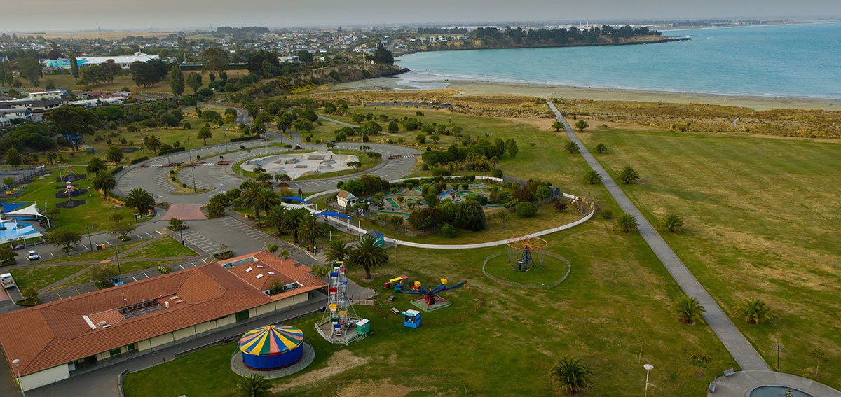
View of Caroline Bay looking North across the carnival area, the playground to the left, the skate park to the center and the Pohatu Koko stream flowing to the sea. Photography by Chris Firkin.

The Sheltering Place: Yankee Sam of Timaru - whaler, settler, publican (26 Jul 1975). Aoraki Heritage Collection, accessed 23/06/2023, https://aorakiheritage.recollect.co.nz/nodes/view/1096
 Edinburgh: Edmonston & Douglas, 1878. Very good overall. Color lithograph from 'The Instructive Picture Book' depicting two sperm whales, a whaling long boat between the whales, a waterspout in the middle ground and a whaling ship in the distance. This color lithograph made using a complicated printing method involving wood engraved detail, hand color and color lithography for the sky portion of the print; this is a multi-block color stone lithograph. With 'Antarctic Regions' below the image, and 'Sperm Whale' to the right; Plate LX in the upper right . - antarctic-regions-sperm-whale-antarctic

Map showing the distribution of whales across different seasons in the mid-19th century. Whaling connected Ngāi Tahu to the global economy in the early 19th century, providing new and sometimes mana-enhancing opportunities for trade, employment, and travel. As the whaling industry declined from the 1840s, some whalers (like Edward Weller) proved transient visitors. Many others, like Howell, remained with their families, though most were not as wealthy. Former whalers turned to fisheries, agriculture and trade. Their mixed communities formed the basis for settlements around the southern region such as Timaur's first perminant European resident Samuel Williams (Yankie Sam). Norman B. Leventhal Map & Education Center, Boston Public Library, CC BY-SA

Sam Williams (1817–1883) was part of the Weller Brothers' whaling gang, and arrived in Timaru in 1839. He later provided valuable insight to the Rhodes family about the area's suitability for sheep farming after leaving the whaling industry. However, Sam's own journey led him to the Victorian goldfields in 1851, where he got married. Returning to Timaru in 1856, he received a cottage from George Rhodes and, with his wife Ann, welcomed the birth of their son, William Williams, the first European child born in Timaru. It's worth noting that Herman Melville, renowned for "Moby-Dick," embarked on his sea adventures during this period, venturing from Fairhaven, Massachusetts, to various whaling vessels.
Whalers once relied on water from Whales Creek, but tidal influences forced them to travel to Nelson Terrace for fresh water. The naming of Caroline Bay originated from the whaling ship "Caroline," which supplied the station. This ship changed hands, was involved in historical events, and was eventually wrecked in Southland. The whaling station met its demise due to bankruptcy, as documented by Dr. Edward Shortland, who recorded his journey from Moeraki to Banks Peninsula in 1844. Following the Timaru whaling station's closure, Sam Williams, the steersman, informed George Rhodes about promising sheep country in the south. This led to the Rhodes Brothers acquiring vast lands in the region, including the Timaru business area.
Captain Blenkinsopp married a Maori woman, the. daughter of a local ; chieftain, and purchased from Te Rauparaha the whole of Wairau Plain. Te Rauparaha repudiated the bargain and the incident had a direct bearing on the Wairau massacre m 1843 which was the beginning of the wars between Maori and pakeha. - paperspast.natlib.govt.nz/Captain+Blenkinsopp
Joseph, George and Edward Weller are immortalised in the folk song “Soon May the Wellerman Come” - circa 1850-1860.
“The song’s lyrics describe a whaling ship called the “Billy o’ Tea” and its hunt for a right whale. The song describes how the ship’s crew hope for a “wellerman” (an employee of the Weller brothers, who owned ships that brought provisions to New Zealand whalers) to arrive and bring them supplies of luxuries, with the chorus stating “soon may the wellerman come, to bring us sugar and tea and rum.” According to the song’s listing on the website New Zealand Folk Song, “the workers at these bay-whaling stations (shore whalers) were not paid wages, they were paid in slops (ready-made clothing), spirits and tobacco.” In the whaling industry in 19th-century New Zealand, the Weller brothers owned ships that would sell provisions to whaling boats. The chorus continues with the crew singing of their hope that “one day when the tonguin’ is done we’ll take our leave and go.” “Tonguing” in this context refers to the practice of cutting strips of whale blubber to render into oil. Subsequent verses detail the captain’s determination to bring in the whale in question, even as time passes and multiple whaling boats are lost in the struggle. In the last verse, the narrator describes how the Billy o’ Tea is still locked in an ongoing struggle with the whale, with the wellerman making a “regular call” to encourage the captain and crew. - denelecampbell.com/more-than-meets-the-ear/


Section on the map showing the Pohatu-koko stream.

Caroline Bay in 1890. Crowd on the beach at Caroline Bay, Timaru, circa 1890. Bathing machines are by the surf. Perhaps this is the stream at the left. Photograph taken by William Ferrier. - National Library. Tiaki Reference Number: PAColl-4746-02

Whales Creek Railway Viaduct at the foot of Wai-iti Rd and Evans Street, Timaru, New Zealand, 1904-1915, Timaru, by Muir & Moodie. Purchased 1998 with New Zealand Lottery Grants Board funds. Te Papa (PS.001051)

Looking south over Caroline Bay from north of the Tennis Courts, c1933. Pohatu-koko stream can be seen to the left, running over the sandy bay. The cars are parked where the playground and tennis courts currently are today. Courtesy of South Canterbury Museum 0076.
The rustic bridge Caroline Bay Timaru circa 1915. Pictures several children on and around the bridge, part of the walkway leading to the Caretaker's Cottage and Tea Rooms on the Bay (in the background). - South Canterbury Museum 2015/150.02


The Tennis Courts Caroline Bay. Timaru. FW Hutton and Co. Timaru. Looking across the tennis courts at Caroline Bay, Timaru showing men playing doubles, houses (left and rear); woman seated (right foreground). Auckland Libraries Heritage Images Collection

1910 Scene at Caroline Bay, Timaru, near the beach with [bowling green ?] And a cropped in image, where you can see Pohatu-koko Whales Creek and a bridge. The Press Collection, Alexander Turnbull Librar Tiaki IRN: 692896. Tiaki Reference Number: 1/1-008906-G. Collection: PA-Group-00103: The Press (Newspaper) :Negatives692896. Tiaki Reference Number: 1/1-008906-G. Collection: PA-Group-00103: The Press (Newspaper) :Negatives

Looking north along Caroline Bay, Timaru. Showing The Pavilion (centre). Over the roof of the Pavilion is the Midland Dairy Company's Palm Butter factory and to its left is Evans Street, with tennis courts beside. A train stretches across the picture from the left. Auckland Libraries Heritage Images Collection

1947 - View to the south Canterbury town of Timaru with Caroline Bay with Evans Street in foreground looking south over the CBD and outer suburbs. You can see the stream running to the sea. Aerial photograph taken by Whites Aviation. Tiaki IRN: 720135. Tiaki Reference Number:: WA-06402-F - PA-Group-00080: Whites Aviation Ltd: Photographs

It is interesting to see the changes to the coastline. This rapidly changed when the new harbour was built.

Refernce to the "old native huts" at the foot of Wai-iti Rd intersection See map here

Early Timaru Book by F. G.. Hall-Jones. Cover and inside page: North Street to Maori Reserve. After A. Wills, 1848 (re-worded). An old map gives Pohatukoko, the same name as the northernAn old map gives Pohatukoko, the same name as the northernreef at the harbour, at the head of the bay on the site ofthe old native huts shown on Wills's map.
"Caroline Bay: It is almost certain that Caroline Bay, the Caroline Har~bour of Golok's sale in 1839, took its name from the whaling barque owned by the Sydney firm of R. Campbell and Company.She was probably the first at Timaru of the many whaling ships which engaged in bay whaling round the New Zealand coast. Blenkinsopp, of Port Underwood, Cloudy Bay, was her captain in the early 'thirties, and in 1834 he shipped in her several escaped convicts at Sydney for his shorestation. The Caroline is mentioned more than once as cruising for sperm whales. In 1837 she was purchased by John Jones, who was then livingin Sydney and who had several shore stations from Waikouaitito Preservation Inlet. She was possibly the same Caroline as the 400-ton barque wrecked at New River Headson April 1, 1860. This barque had been purchased by Jones Cargill and Company, who intended to convert her into a storeship at lnvercargill.The try-pot now at Caroline Bay was found, encrusted with shells and barnacles, by Mr. A. Bennett in the shingle a little to the south of Patiti Point, where presumably a whale had once been brought ashore. Mr. Bennett used it for many years as a watering trough in his yard at Patiti. It then went to Sutherlands and was eventually placed at the bay. The Maori name is preserved in a jotting by Mantell in 1848, "Te Kaio tauraka in Caroline Bay", (Kaio, probably the ngaio tree; tauranga, an anchorage or a place of abode.) An old map gives Pohatukoko, the same name as the northern reef at the harbour, at the head of the bay on the site of the old native huts shown on Wills's map."
- EARLY TIMARU, F. G. HALL- JONESTIMARU, F.G.HALL-JONES

1856 Map of the Province of Canterbury, Archives New Zealand. When you zoom in over Timaru, you can see the reserve for the township and Caroline Bay. Item reference: AGCO 8368 IA36 4/12 (R22420403)

The earliest European reference to Timaru as such occurs in the whaling journals of 1839 where it was described as “Ternurdu.” The first mention of “Caroline” occurs in mem orials concerning the sale of land by Māori to the Weller Brothers in 1939, when the Bay was described as “Caroline Harbour." That the name "Timaru" was applied to the whole Bay as shown by an official notice in the Lyttelton Times of October 22. 1851, concerning “land which is to be laid off as a town at Timaru Bay."
One of the earliest references to the name "Caroline Bay" is on a 1868 chart of New Zealand by James Wyld Sr. (1790-1836) was a British cartographer and one of Europe's leading mapmakers. “Caroline Bay and Pateti Pt & Rf.” are shown just north and south of Timaru township.

Section of the mural at Caroline Bay by J .L. Wilson 2002. LEFT Kaiti, chief of Arowhenua kainga. RIGHT. Te Rehe. Photography Courtesy of Roselyn Fauth
In 1844 Edward Shortland crossed the streams running down to Caroline Bay, noting it as “the only spot where a boat can find shelter between Bank’s Peninsula and Te Awa-mokihi”. Guided by Te Rehe, Rangatira of Te Waiateruati Pā, he walked to Te Aitarokihi (what the whalers called ninety-mile beach). On the shores of Waitarakao (the Washdyke lagoon) he found a hut where Māori woman were drying fish about the size of whitebait on the hot sand. After getting lost in a harekeke swamp he spent the night at Te Waiateruati Pā.

1820-1895 :Tauamotu. Timaru. Camp of natives windbound. 17 October 1848 - Looking south along the beach line near Timaru towards a figure on the beach at a small campsite with a boat drawn up on shore. Mantell's three Māori porters are walking above the beach on flat land studded with cabbage trees towards a low hill - natlib.govt.nz/134166