- Before 1870: Ships anchored in the open roadstead and were loaded/unloaded by surf boats.
- The landing service was operated by Captain Cain and H. J. Le Cren, who employed six Deal boatmen from New Zealand.
- On fine days, surf boats could handle significant cargo. For example, in 1875, 170 bales of wool were loaded onto the schooner Spray in one day.
- The Shaw Savill liner "Gothic" (15,911 tons gross) was the largest ship to visit the Port of Timaru.
- 1852: The first trading vessel visited Timaru.
- 1861: Timaru was declared a port of entry due to increasing trade.
- 1878: Construction of a 300-foot breakwater began, completed in stages, and extended to 2,000 feet by 1887.
- Following the breakwater, the Marine Parade was constructed.
- 1900: The Eastern Extension work began.
- By the end of 1906, half a million tons of rock were used in the construction of the 3,000-foot wall.
- Timaru is the third-largest port in New Zealand for the export of frozen meat, particularly frozen mutton to Britain.
- 1852: The first trading vessel visited Timaru.
- 1861: Timaru was declared a port of entry due to increasing trade.
- 1878: Construction of a 300-foot breakwater began and continued in stages until it reached 2,000 feet by 1887.
- After the breakwater, the Marine Parade was built.
- 1900: The Eastern Extension work started.
- By the end of 1906, half a million tons of rock were used to complete the 3,000-foot wall.
- Timaru is the third-largest port in New Zealand for exporting frozen meat, including frozen mutton to Britain.
- Timaru and South Canterbury New Zealand 1959: the City and the Province to-day with some interesting glances at the past. Aoraki Heritage Collection, accessed 05/03/2025, https://aorakiheritage.recollect.co.nz/nodes/view/481
- 1839 March 28th: The Dublin Packett left Otago for Te Murdo with the whaling gang on board.
- 1839 September 16th: Honduras returned to Otago with Timaru oil.
- 1840 April 20th to May 4th: The Sarah and Elizabeth was at Te Murdo putting the gangs ashore and unloading stores.
- 1840 July 1st: A boat's crew from Timaru arrived at Banks Peninsula and signed articles.
- Mid-1840s: Another whaling company is believed to have operated off Timaru, but it is unclear if it had a shore station.
- 1844: E. Shortland made a trip along the coast and published a reference to the disused whalers' huts near Timaru.
- 1848: W. Mantell visited the area, sketched Caroline Bay, and reported no water except at a hole called Po-niu-a-pine.
- 1849: C.O. Torlesse made surveys of South Canterbury, reporting that whaling ships frequently anchored in Timaru and were able to ship produce to Port Victoria.
- 1851 October 22nd: The Lyttelton Times published a notice by Lieutenant-Colonel James Campbell about a town to be laid off at Timaru Bay.
- 1856: Henry Sewell reported negatively about Timaru as a shipping place but would later seek nomination as a representative of Timaru on the Provincial Council.
- 1857: Archdeacon Henry Harper made a journey from Christchurch to Moeraki, noting whalers' huts at Timaru and predicting the area's future as a harbour.
- 1857: The Provincial Government took notice of Timaru, referring to reports that showed its potential as a shipping port.
- 1859: LeCren's landing service was founded, marking a new chapter in Timaru's port history.
- 1859: Captain Henry Cain, involved with loading wool in 1857 and the establishment of LeCren's landing service, began to play a key role in Timaru’s port development.
- 1864: LeCren's landing service was taken over by the Provincial Government.
- 1879 November: The ketch Prince Rupert unloaded timber directly to the Timaru breakwater.
- 1886: Captain Henry Cain became one of the victims of the poisoner Thomas Hall.
- Late 1800s: Railways Department commissioners tried to hinder the Port of Timaru by imposing special taxes on coal and timber and altering freight rates to divert trade to Lyttelton.
- 1989 September 8th: The Timaru Herald reported on past battles between the port and bureaucratic challenges, warning local leaders to be vigilant regarding the port's future.
- Doug Shears, Tales of South Canterbury Vol. 2 : Ships named Timaru . Aoraki Heritage Collection, accessed 04/03/2025, https://aorakiheritage.recollect.co.nz/nodes/view/8181

Notable characters in the port story
- Mr. William Evans:
- Chairman of the Timaru Harbour Board since about 1882.
- Known for his keen interest in the welfare of the port.
-
- Also associated with the Atlas Roller Flour Mills.
- Mr. George Lyall, J.P.:
- Member of the Timaru Harbour Board.
- Engaged in farming and pastoral pursuits before joining the board.
- Actively involved in various community organizations and initiatives.
- Mr. John Manchester:
- Represents the Makikihi riding of the Waimate county on the Timaru Harbour Board.
- Previously served as Mayor of Waimate.
- Mr. Alexander Campbell Pringle, J.P.:
- Member of the Timaru Harbour Board since 1893.
- Engaged in farming and pastoral pursuits before joining the board.
- Involved in various other organizations including the Canterbury Land Board and Land Purchase Board.
- Mr. David Clarkson Turnbull:
- Member of the Timaru Harbour Board since March 1900.
- Established the firm of D. O. Turnbull and Co., grain and produce merchants.
- Mr. William Julian Bardsley:
- Secretary and Treasurer of the Timaru Harbour Board.
- Selected for his position in 1902 among thirty-three applicants.
- Mr. Albert Ernest Austin, A.M.I.C.E.:
- Engineer to the Timaru Harbour Board.
- Previously engaged in various engineering projects including railways and water works in Brazil.
- Captain Thomas Nicolson Clarkson:
- Harbourmaster and Pilot at Timaru since 1886.
- Began his career at sea and obtained his master's certificate at the age of twenty.
- Mr. Peter Sinclair:
- Foreman blacksmith at the Timaru Harbour Board's engineering works.
- Previously engaged in ship-smithing and business ownership before joining the board.
Timaru Herald, 10 January 1882, Page 2
Theatre Royal. There was crowded house at the Theatre Royal last evening to greet Lyons' Tourist Party, on their second appearance in Timaru. The hit of the evening was made by Miss Horton, when she gave the following impromptu verses:
Our Breakwater is very near completed,
Of its success there's not the slightest fear,
We soon will have a safe and handy harbor
If Captain Sutter does not choke the Engineer.
They quarrel over nothing every meeting,
And fight about the gravel and the Bills,
But their fuss about the harbor and the Cashmere,
Was blighted by our old friend Captain Mills.
THE TlMARu HERALD Wednesday, January 14, 2009
"The official beginnings of Timaru Harbour could well be marked by a Government Gazette notice of September 1865. It declared Timaru a port of entry, the extent of the port being defined as "a circle of one mile radius, whereof the centre is the centre of the Market Place; and the beach at Timaru, to the extent of 40 chains measured along the line of the beach in each direction north and south of the small stream watercourse which crosses the Market Place, shall be deemed to be the local quay or landing place for the landing of goods under the Customs Regulation Act, 1858."
The merits of the various landing sites were vigorously argued between Rhodes Town and Government Town advocates, but the first Harbour Commission, which reported to the Provincial Government in 1864, decided in favor of the Rhodes Town site, at the foot of Strathallan Street. From the early 1840s, when whaling was carried on in the bay, ships of all kinds had used the roadstead, described as providing good anchorage except during south-easterly gales—probably the first official recognition of Timaru's potential as a port.
Small trading ships seem to have been calling regularly from the early 1850s onwards, bringing essential supplies to the first settlers and taking wool from the Levels station, worked by the Rhodes brothers. In 1857, the merits of the roadstead were again drawn to the attention of the Provincial Government. One report, by Lyttelton Captain C. Conradi of the ship Highlander, suggested that with good moorings, Timaru could be safely visited by "large vessels."
As for harbour construction, the commission dismissed the idea of building any type of jetty, wrote off a breakwater, mole, or other retaining wall of masonry as too costly, and submitted that the only thing to do was to improve the landing-boat service as a means of coping with Timaru's expanding trade. Local opinion was incensed by this write-off of harbour hopes, and the Government was induced to look further at the problem. Proposal followed proposal, but in the meantime, vessels were being wrecked in alarming succession.
By 1873, the public demand for action had become so strong that the Provincial Government asked its agents in London to commission a report from reputable consulting engineers. Designer Sir John Coode recommended a scheme to cost about £250,000, including a wall 1300 feet long, parallel with the coastline, a pier, and a viaduct to permit the northward drift of the shingle. At the same time, Lyttelton engineer Mr. Isaac Jacobsen put forward a proposal to convert the Milford lagoon, at the mouth of the Opihi River, into a harbour.
After some further fact-finding, it was decided by the harbour board—the first board had been elected at the beginning of 1877—to proceed with the construction of a 300-foot mole, built of concrete blocks, as proposed by the engineer Mr. John Goodall. The first wharf was built as the building of the mole proceeded. The shingle accumulation south of the mole posed a problem, but it was concluded at that stage that dredging was the cheapest and most effective way to deal with it. Then a sandbank began to form at the harbour entrance, and to correct that, further wall extension was found to be necessary.
The shingle question came to a head in 1898 when pounding southerly seas tipped thousands of tons of shingle over the breakwater into the harbour. When the entrance became partly closed, it seemed obvious that the shingle-drifting policy would have to give way to something more positive, and it was decided to build an extension from the beginning of the curve of the concrete breakwater. This idea was put forward by Wellington consulting engineer Mr. J. P. Maxwell.
One more commission looked at the situation and approved the extension idea, and the board was finally empowered to borrow £100,000 for the purpose. This touched off a lively loan campaign, during which more than 20 meetings were held throughout South Canterbury, with speakers having to submit to a barrage of questioning. But the loan proposal was approved handsomely by the ratepayers—by 2065 votes to 754.
Work had hardly begun on the first stage of the extension project when the sea breached the concrete breakwater, thus emphasizing that urgency was the essence of the contract. The board took this view in 1901 when, to enable faster progress, it took over the construction job from the contractors. The planned 3000-foot extension was completed in 1906, when nearly half a million tons of rock had been tipped at a cost of about £136,000. By 1914, the wall had been taken out to 3474 feet and had cost about £150,000."
- Timaru 1859-2009, Celebrating 150 years. Aoraki Heritage Collection, accessed 12/09/2024, https://aorakiheritage.recollect.co.nz/nodes/view/3330
1880 Photograph by the Press of the Breakwater in Timaru. Tiaki IRN: 692816. Tiaki Reference Number: 1/1-008819-G. Collection: PA-Group-00103: The Press (Newspaper) :Negatives
1884 Standard survey of the Town of Timaru, Canterbury N.Z. / H. Maitland surveyor. Wellington, N.Z. Photolithographed at the General Survey Office. Sourced from LINZ. Crown Copyright reserved.'Notes Archived by the National Library of New Zealand
Map of the Province of Canterbury, New Zealand showing the pasturage runs : compiled from official surveys, under authority of the Provincial Government, and from recent explorations by Dr. Haast, provincial geologist, Canterbury & Dr. Hector, provincial geologist, Otago / by J.S. Browning, Survey Office ; drawn by Alfred Jarman, Survey Office, Christchurch. - Christchurch [N.Z.] : Survey Office
South Canterbury’s northern and southern boundaries were large, snow-fed rivers Waitaki and Rangitata that were difficult for early travellers to cross. Travelling by sea was easier.
1838 First mention of Timaru that we knowThe first mention of Timaru that we knowof occurs in the journal of Octavius Harwood, who was foremanand clerk at Weller Brothers' whaling station at Otago.The journal, which is preserved in the Hacken Library inDunedin, commences on April 24, 1838. ""March, Thu. 28th. Schooner D.P. sailed for"March, Thu. 28th. Schooner D.P. sailed forTemurdu with Brown's gang on board-shipped twonatives, Tomahawk and Rootie, for Brown's gang-issuedclothes for same. . ."
1839 Whaling station in Timaru. "( 1839) "Aug. 31: Received letter from Mr. Brown.( 1839) "Aug. 31: Received letter from Mr. Brown.States wants provisions-had two casks beef-two 180 ofbread, half cask flour, one week's sugar on the ground.Had got 70 tuns of oil with tonguers and about nine tunsmore casks remaining."
1840 The Sale of "Timeru Flat" On 15th January, 1840, Edward Weller informed his brotherOn 15th January, 1840, Edward Weller informed his brotherthat he had bought " the land between the rivers atTimeru Flat" from Tuawaik (Tuhawaiki) for £ 10. Reverend Thomas Aitken and James Aitken purchased 2,560 acres from George Weller. None of the Weller claims were prosecuted before the Lands Claims Commissioners, and all were disallowed.
1844 Hone Tūhawaiki drowned 5km south of Timaru. Also known as John Tūhawaiki, and 'Bloody Jack' by the sealers of Foveaux Strait, he was the leader of Kāi Tahu in Murihiku but spent a lot of his time travelling Kāi Tahu territory. The point where he drowned now bears his name: Tuhawaiki (Jack's) Point, and is commonly known to locals as Jack's Point. "His commercial ability impressed European observers, who noted that he spoke English freely, could read and write a little, and was accustomed to cash transactions and bank business. On business he dressed in a neat suit and white greatcoat, and wore a watch and chain." - teara.govt.nz/en/biographies/1t110/tuhawaiki-hone
1848 Mantell made a sketch of Timaru Harbour across Caroline Bay.
1851 - Brothers William and George Rhodes founded the Levels run. They used the sheltered shore at Timaru, to land stores and ship wool. Timaru’s first building was a cottage on the beach, and the first permanent inhabitant was Sam Williams, the whaler who introduced George Rhodes to South Canterbury.
In 1853 the Rhodeses bought land behind Caroline Bay and laid out a town. In 1856 the government surveyed a second town to the south, but because of its superior landing places it was the brothers’ town that prospered. Eventually, the two settlements merged.
1856 ‘Timaru is a miserable apology for a shipping place without wood or water. Nothing will ever spring up there but a public-house, a store and a woolshed.’ - Said Henry Sewell, Christchurch-based politician when he visited Timaru
1857 Belfield Woollcombe was appointed as government agent, an all-purpose official.
1857 Archdeacon Harper mentioned Timaru on his travels southward from Christ~church "". . . coming on a bay enclosed by low cliffs, found". . . coming on a bay enclosed by low cliffs, founda solitary hut occupied by an old whaler and his wife,who gave me dinner and directed me to ride along thebeach . .. The bay, which is a pretty piece of coast scenery,has a Maori name Te Maru, 'the place of shelter', wellnamed, as it was used by whalers as a landing place wherethey could try out their oil. Sam Williams showed mesome of their trypots still remaining on the beach, and Ispent a pleasant hour with him listening to his yarns ofthe old days ....
1859 100 British settlers arrived to Timaru on the Strathallan. At the time Timaru had only five houses.
1860s Mail and coach services linked Timaru to Christchurch and Dunedin from the 1860s, before the rivers were bridged.
1862–63 further 360 immigrants arrived.
1866 the town had a population of 1,000
1868 Timaru became a borough
1870s The population doubled.
1872 The Rangitātā River was bridged at Arundel. This remained the main road bridge over the Rangitātā until the present bridges at downriver Rangitātā Island were built in the 1930s.
1896 until 1911 there was relatively high growth, linked to more intensive farming in the region.
1948 Timaru became a city
1855 Samuel Hewlings surveyed the coastline southwardSamuel Hewlings surveyed the coastline southwardfrom Timaru. His field book gives us a sketch map ofthe sharp headland at Paparoa, showing both the cliffs andthe high-water mark. At the top of the cliff, close to wherethe lighthouse was later built, he indicated a tablet "October 13, 1824. This is the month Tu Hawaikitiki died. He died at Paparoa and was removed to TeHu."
1858 The first landing service was opened at the bottom of Strathallan Street. It was bought by the government in the mid-1860s and used for the first shipment of wool direct to England. Entrepreneurs later set up a private service in competition. The George Street landing service building is one of Timaru’s oldest structures.
1860s Timaru’s leaders realised that the landing services, which required double-handling of cargo, were restricting the port’s growth. They initiated plans for an artificial harbour to provide wharves and a safe haven for ships. Opponents thought that because Christchurch’s port at Lyttelton was soon to be linked to Timaru by rail, a local harbour was unnecessary. But the scheme went ahead, as advocates believed that without its own harbour, the town would decline.
1860s Lime-burning, for agriculture and building, began. Limestone was also quarried as a building stone, and bricks were fired locally, most importantly near Makikihi. Lime is still quarried extensively for agricultural use.
1870s Large-scale wheat growing began. Peaked in the early 1900s. Much of the wheat was grown by contractors who leased land from the estate owners..
1877 The Waitaki was bridged at Glenavy and between Kurow and Hakataramea in 1881.
1878 Construction gets underway of a main trunk railway between Christchurch and Dunedin. Completed in 1878, it linked Timaru to both cities, and to Temuka and Waitaki North (Glenavy) along the way. South Canterbury had only two significant branch lines. The line from Washdyke reached Pleasant Point in 1875 and was opened to Eversley, beyond Fairlie, in 1884. The line from Studholme Junction to Waimate opened in 1877. It was extended to Waihao Downs in 1883. In 1881, the branch line in North Otago to Kurow was extended across the Waitaki River to Hakataramea. A proposed line up the Hakataramea Valley was never built. The last of South Canterbury’s branch railway lines closed in the 1960s.
1878 Work began on the construction of the 700-metre southern breakwater.
1878 The first of the large brick flour mills along the railway line at Timaru was built. New Zealand’s first roller mill began production in this area in 1882. Later, these mills also produced oatmeal, pasta and stockfood. Flour and stockfood are still made in Timaru.
1880s, the northern breakwater was built to keep sand shoals out of the harbour.
1882 The first attempt was made on Aoraki/Mt Cook, New Zealand’s highest mountain (then 3,764 metres). It was first climbed by the New Zealanders Tom Fyfe, George Graham and Jack Clarke in 1894. In 1948 a young climber, Edmund Hillary, was in a party which made the first ascent of the mountain’s south ridge. Five years later he and Sherpa Tenzing Norgay were the first to climb Mt Everest. The face-climbing era that began in the 1950s culminated in the first ascent of the Caroline Face in 1970.
1883 Timaru had one wharf 880 feet long. Five years later the Moody Wharf was built and was extended in 1905. No. 3 Wharf was built in 1908, since when all the wharves have been altered to make them more efficient. The total berthage space is 3,400 feet. A wharf for fishermen was built in 1911.
1883 Before refrigeration, surplus stock was disposed of in boiling-down and meat-preserving works at Pleasant Point, Washdyke and Milford. The South Canterbury Refrigerating Company, formed in 1883, built a freezing works near Timaru in 1885. In January 1886 its first cargo of frozen meat was sent directly from Timaru to the United Kingdom. The works were rebuilt in the 1890s, reopening as the Smithfield Works in 1898. In 1904, the Christchurch-based Canterbury Frozen Meat Company built a second South Canterbury works at Pareora.
1880 Sawmilling and lime-burning were two of South Canterbury’s earliest industries. The timber industry had more or less ended by 1880, after fires destroyed the remaining forests at Waimate and Geraldine.
1883 A butter factory was established in Temuka in 1883, and a cheese factory at Geraldine in 1884. Dairy exports through the port of Timaru increased fivefold between 1911 and 1927. More butter factories were built in Waimate and Timaru, and cheese factories in Clandeboye, Ōrari and Milford.The factory at Clandeboye now draws milk from about 600 farms between North Canterbury and Otago. The factory produces specialist cheeses and other products from 11 million litres of milk a day, and employed 750 people in the early 2000s.
1899 - 1906 the eastern extension of the main breakwater was completed, preventing shingle drifting north into the harbour. During the 20th century the breakwaters were extended, realigned and raised.
1903 - Imports and exports during the six months ending June 30 last totalled 73,312 tons, valued at £586,514, and whose shipping tonnage during the same period amounted to 193,504 tons. Timaru ranks third in importance in the matter of exports, having sent away during the first six months of this year 463,498 carcases. - trove.nla.gov.au/128462244
1906 In the 19th century New Zealand flax was cut and milled at Waimate, Winchester and Fairlie, but the last significant shipment of flax fibre left in 1906. During the Second World War a linen flax industry was established as a wartime measure. Four factories were supplied from more than 3,000 hectares. By the late 1950s, less than 300 hectares was being planted in linen flax. The lifting of protective tariffs and competition from synthetic fibres reduced demand. The last factory, in Geraldine, closed in the late 1970s. Wool was scoured at Washdyke from the days of the early runs, and a woollen mill was built in Timaru.
1906 Rodolph Wigley founded the Mt Cook Motor Service, which leased the Hermitage hotel from the government between 1922 and 1945, and became a major tourist company. In 1955 his son, Harry Wigley, landed a ski-equipped plane on the Tasman Glacier, starting a new era in tourism at Aoraki/Mt Cook.
1907 A Dredge 'The Taniwha' was purchased to keep the harbour entrance clear.
1911 Flour milling became an important industry in Timaru and Waimate, and wheat and flour were exported through Timaru’s port. The peak export years were 1911 for wheat and 1913 for flour. Wheat growing declined during the First World War, and by 1924 wheat was being imported to keep the mills operating.
1920 South Canterbury’s first public airport was formed at Washdyke. A small airfield built at Saltwater Creek in 1931 was used for commercial flights, and by the South Canterbury Aero Club. In 1953 a new airport was opened at Levels. Regular air services between Christchurch, Timaru and Ōamaru began in 1956. Improvements to State Highway 1 reduced the need for flights to Christchurch, but there are still twice-daily flights to and from Wellington.
1963–67 An all-weather meat loader was built. A second northern breakwater allowed land to be reclaimed for cargo storage and a fish processing factory.
The building of the harbour changed the coastline at Timaru dramatically. Shingle accumulated south of the harbour, and this new land was used for grain and wool stores and oil tanks. North of the harbour, sand piled up under the clay cliffs to form the beach of Caroline Bay.

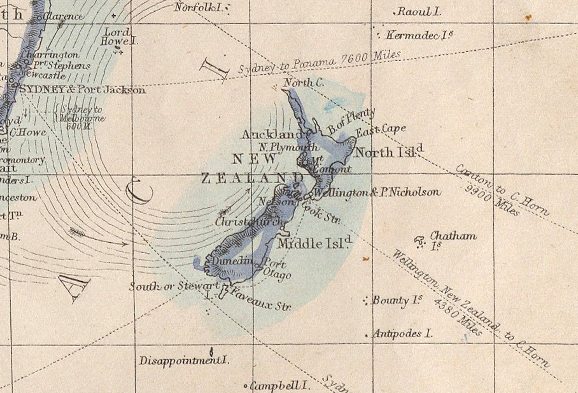
The world on Mercators Projection. This dispatch atlas was printed in the Weekly Dispatch London 1863 and was created by Weller, Edward, 1819-1884. From the David Rumsey collection
And a close up of New Zealand on this Atlas.

1861 Shows coastline from headland to the south, with trees and houses up from the water's edge. Hills and mountains are in the background by Barton, Cranleigh Harper, 1890-1975 - Shows coastline from headland to the south, with trees and houses up from the water's edge. Hills and mountains are in the background.

View of Timaru Harbour 1877. View looking north along the waterfront, with sailing ships, men beaching a boat, and a large building, probably Belford Steam Flour Mill near the waterfront, alongside other wharf or factory buildings. From a sketch books held by Hocken Library. By Fanny Wright Brunton - https://tiaki.natlib.govt.nz/#details=ecatalogue.59362

C1877 The Roadstead, Timaru, N.Z. Engraving of Timaru from the original edition of the Illustrated Australian News.Courtesy of Fauth Private Collection.
Illustrated Australian News (Melbourne, Vic. : 1876 - 1889) Wed 3 Oct 1877. Page 155 TIMARU, CANTERBURY, NEW ZEALAND..
At the time it was reported that the town contains nearly '3000 inhabitants, and the district between 13,000 and 14,000. There is railway communication with Christchurch, and southwards to Dunedin.
"The grazing capabilities of the district are very great, and the export of wool is about 15,000 bales. The soil and climate are admirably, adapted for wheat and other cereals, and the last harvest yielded more than 1,500,000 bushels of wheat and oats alone. The trade of the district requires greater facilities for shipping produce than are afforded by an open roadstead, and harbor works for tho improvement of the port have been in progress for some time past. The rapid advance made by the town and district in commeroial matters may be understood from the fact that in 185S one whaleboat was sufficient to carry all the wood produced off to the vessels anchored in ' the roadstead and land the requisite supplies, while now a large number of surfboats, carrying from twenty to thirty tons each, are profitably employed in the trade. Our illustration shows the coast line, the roadstead, and a portion of the town viewed from the south." - trove.nla.gov.au/newspaper/article/60096457/5730320#

The Norman McLeod is being towed out in Timaru Harbour - 1895-02-23 - Auckland Libraries Heritage Collections NZG-18950223-0180-01

Wise's N. Z. directory plan of Timaru 1870-1879 shows a proposed Jetty at the foot of Strathallan Street - Auckland Libraries Heritage Collections Map 6537a
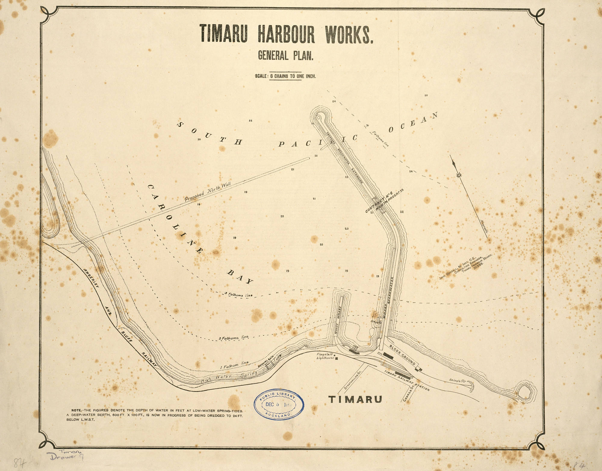
A map of the works to be carried out in Timaru Harbour 1886 - Auckland Libraries Heritage Collections Map 3837

Timaru, circa 1883, Dunedin, by Burton Brothers. Te Papa (C.014380)

Timaru, 1800s, Dunedin, by Burton Brothers. Purchased 1999 with New Zealand Lottery Grants Board funds. Te Papa (O.034093)

Close up of a boat - Timaru, 1800s, Dunedin, by Burton Brothers. Purchased 1999 with New Zealand Lottery Grants Board funds. Te Papa (O.034093)
![A-180-018: [Lysaght, Mary Grace Caroline] 1850-1935 :From Timaru, of Mount Peel, Mount Somers & Mount Hutt [ca 1880]](/images/nlnzimage_14.jpg)
Looking across bay to the Alps, two sailing ships sketched in 1880 - A-180-018: [Lysaght, Mary Grace Caroline] 1850-1935 :From Timaru, of Mount Peel, Mount Somers & Mount Hutt [ca 1880] - Alexander Turnbull Library, Wellington, New Zealand

Ship Lyttelton off Timaru 1883. Oil on Canvas by Laurence Wilson. Auckland Art Gallery Toi o Tāmaki, gift of Mrs A Scott, 1946

Engraving showing the Timaru Breakwater 1888. Picturesque atlas of Australasia"; The Picturesque Atlas Publishing Co.
Breakwater, Timaru 1885. Albumen print by Walter Burton, Alfred Burton. Auckland Art Gallery Toi o Tāmaki, purchased 1976
Shipping at Timaru, New Zealand in the 1880's. From a volume titled 'New Zealand Owned Shipping Lines and Early Shipping Views'. This section comprises New Zealand Owned Shipping Lines. New Zealand Early Shipping Views. This image is from the A.D. Edwardes Collection of about 8,000 photographs, mostly of sailing ships from around the world, taken between about 1865 and 1920. Mounted in 91 albums, the photographs are arranged by country of ownership, with some special volumes such as 'Shipping at Port Adelaide' and 'South Australian outports'. Additional information, giving the history of the ships where known, has been provided by maritime historian, Ron Parsons.
https://collections.slsa.sa.gov.au/resource/PRG+1373/42/45
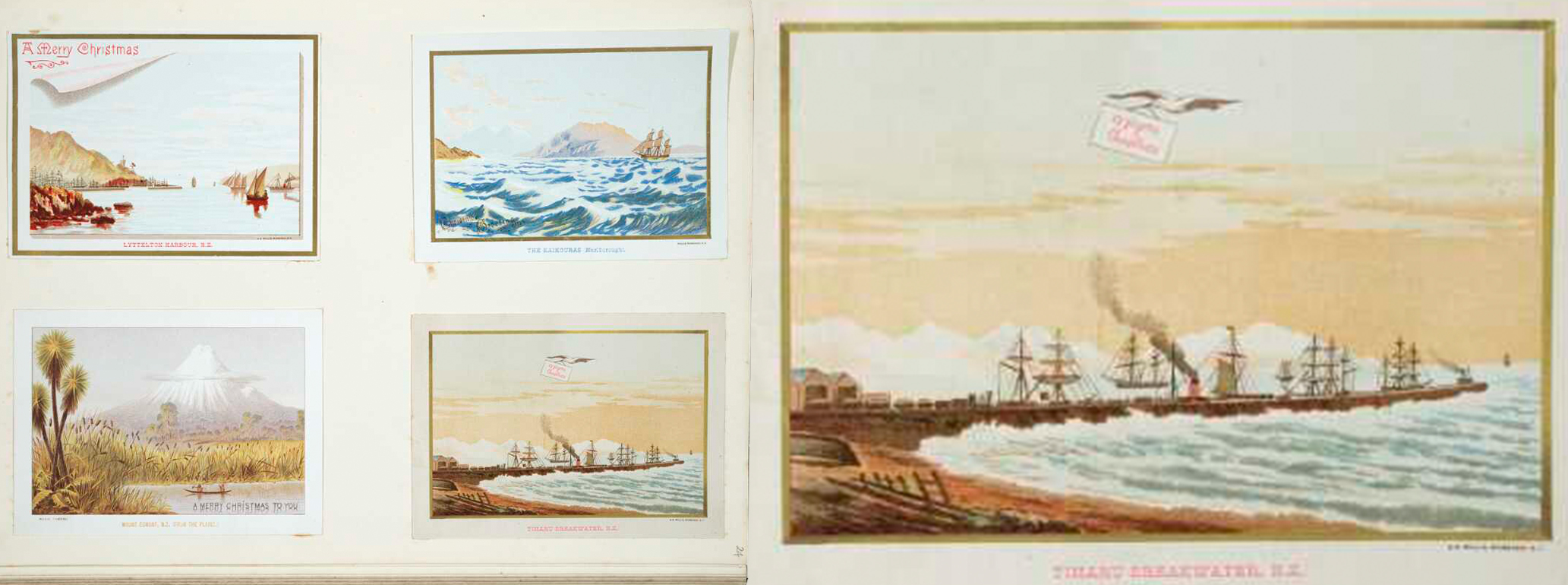
Page of coloured chromolithographs showing New Zealand landscape scenes, prepared as greeting cards and presented in a sample album by Archibald Dudingston Willis (Firm) :Lyttelton Harbour, N.Z. The Kaikouras (Marlborough). Mount Egmont, N.Z. (from the plains). Timaru breakwater, N.Z. [ca 1885] Ref: E-936-f-024. Alexander Turnbull Library, Wellington, New Zealand. /records/30112552
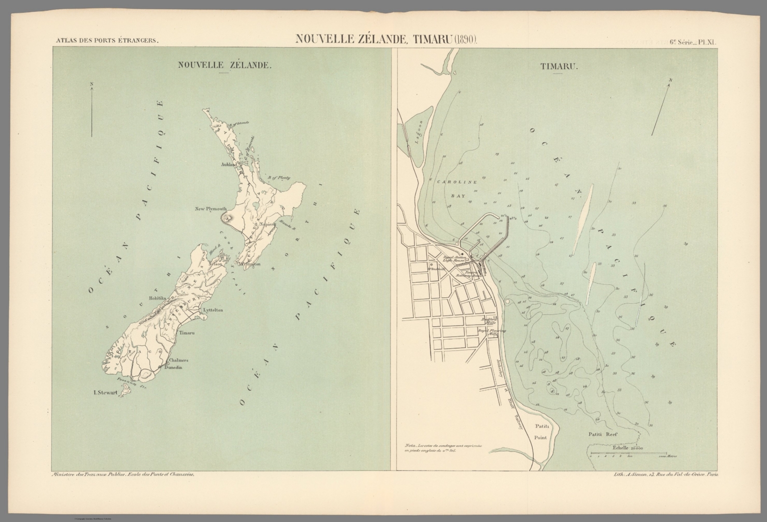
New Zealand and clost up 1890 map shows the Port of Timaru. Feature topography; railways, streets, bridges, drainage, docks and soundings, with depths given in meters. Bookplate title pasted to verso: Pl. XI. Nouvelle-Zélande, Timaru. Appears in Sixième livraison. 14306154-DavidRumseyMap Collection-David Rumsey Map Center-Stanford Libraries

New Zealand Post Office directory map of the town of Timaru and suburbs, compiled by Smith and Boys shows the Breakwater loading warf, Warf No2, Lighthouse and the Baths. - 1887 - Auckland Libraries Heritage Collections Map 6621
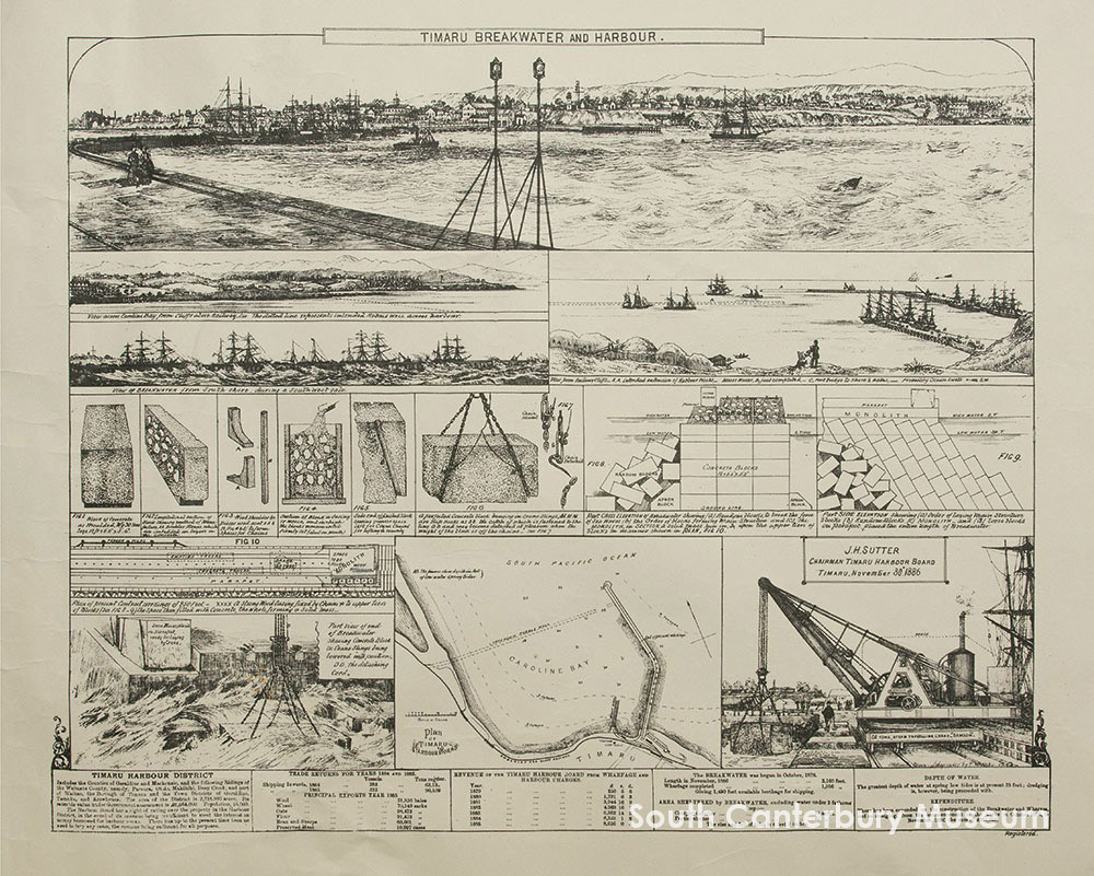
Sketches and plans entitled "Timaru breakwater and harbour", showing the construction of the breakwater begun in 1878 and completed in November 1886. Produced to celebrate the completion of the project. Image courtesy of the South Canterbury Museum CN 2010/153.01.
The proposal to build a new port at Timaru was surprisingly contentious and hotly debated. Opponents thought that because Christchurch’s port at Lyttelton was soon to be linked to Timaru by rail, a local harbour was unnecessary. But the scheme went ahead, as advocates believed that without its own harbour, the town would decline.
The breakwater design by engineer John Goodall was adopted and work started on the redevelopment of the artificial port in 1877. The first
The sixty-ton ketch Prince Rupert was the first to moore at the stump of a breakwater. Two days after the contract was completed, a public ceremony was held to celebrate. They ate dinner and fired rockets.
Sand washed south down the shoreline and began to build up against the northern mole, covering the rocky beach. This was the beginning of the extensive land reclamation around the Caroline Bay district, an area which is still growing today.
Work began in 1878 with the construction of the 700m southern breakwater. In the late 1880s, the northern breakwater was built to keep sand shoals out of the harbour. Between 1899 and 1906 the eastern extension of the main breakwater was completed, preventing shingle drifting north into the harbour. During the 20th century the breakwaters were extended, realigned and raised.
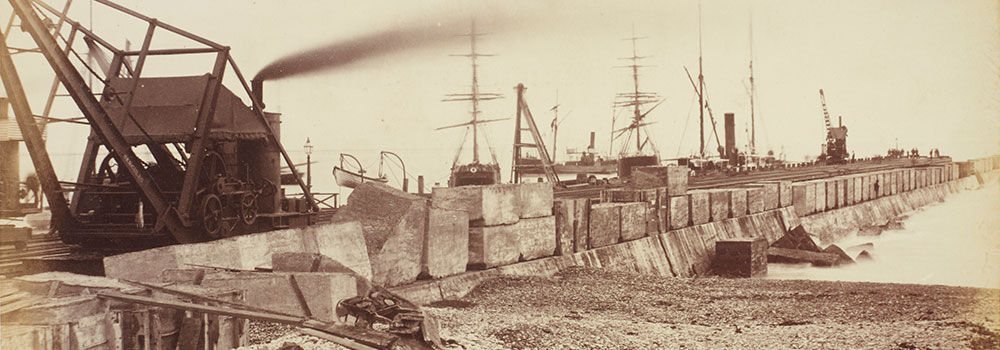
Timaru Breakwater. From the album: Scenes of New Zealand, circa 1880, Timaru, by Messrs F. Bradley & Co. Te Papa (O.042435)

The breakwater, Timaru, photographed ca 1910-1913 by William Ferrier - natlib.govt.nz/263897
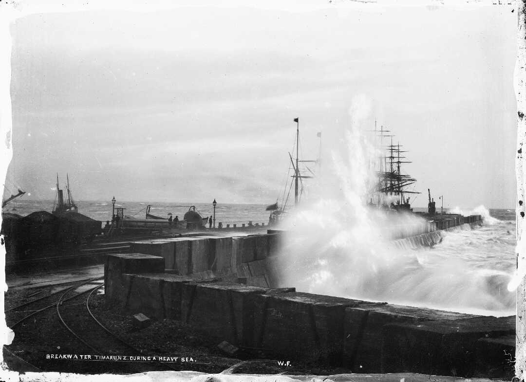
Timaru breakwater photographed by William Ferrier circa 1896-1899. - natlib.govt.nz/85664

Timaru Harbour & Breakwater, circa 1904, Canterbury, by Muir & Moodie. Purchased 1943. Te Papa (PA.000203)

Harbour Improvements At The Capital Of South Canterbury. Auckland Weekly News, 2 March 1911, p.14. Auckland Libraries Heritage Collections AWNS-19110302-14-01 https://kura.aucklandlibraries.govt.nz/digital/collection/photos/id/193668/rec/51

Timaru, by Muir & Moodie. Te Papa (C.014801)

Timaru Harbour from Melville Hill, 1904-1915, Timaru, by Muir & Moodie studio. Courtesy of Te Papa. Purchased 1998 with New Zealand Lottery Grants Board funds. (PS.001046)

Timaru, New Zealand, 1912, Timaru, by Muir & Moodie. Purchased 1998 with New Zealand Lottery Grants Board funds. Te Papa (PS.001029)
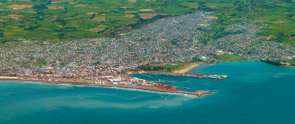
View of the Port from the sky in 2014. Photograph by Geoff Cloake.
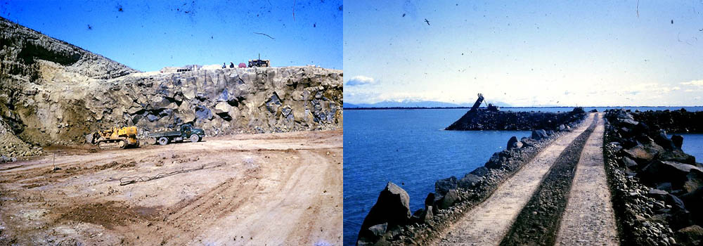
Port construction continues in 1964. LEFT Loading rock at the Quarry on Kellands Hill for the North Mole extension at Timaru Port. The loads from Kellands Hill went Pages Rd, SelwynSt, White St onto Evans St then down to the bay and across the sand. RIGHT: Kellands Quarry Rock being tipped on to the North Mole at Timaru Port 1964. Photograph by George Kinch

Harbour Board Quarry, Timaru, New Zealand, by Muir & Moodie. Te Papa (C.014398)

Railway carts on display at the Pleasant Point Museum. These were used to move rock from the quarries to the harbour. Photo by Roselyn Fauth 2022
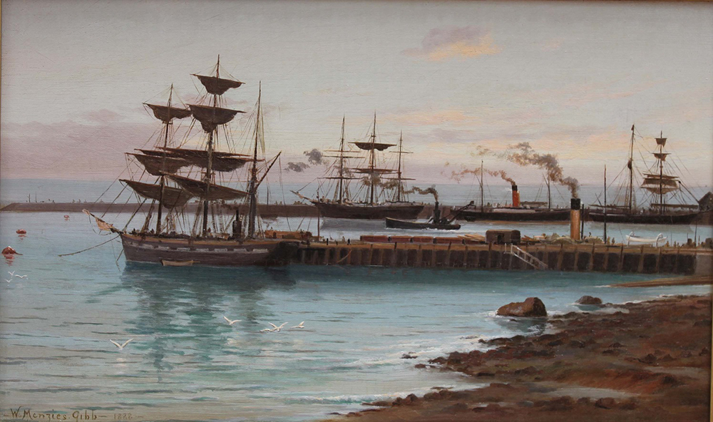
William Gibb (1859-1931) Timaru Harbour, 1888, Oil on canvas, Aigantighe Art Gallery Collection 2002.10
William Gibb was born at Innellan, Scotland and immigrated to Christchurch in 1876. He received his art training from his father, John Gibb (1831-1909), and then studied at the National Gallery School in Melbourne from 1877 to 1879. He returned to Christchurch in 1882 and painted portraiture and landscapes. In Timaru Harbour, Gibb has painted a snapshot of the shipping industry and the newly built wharves. Previously, ships anchored offshore and used smaller boats to transport their cargo ashore. But by the late 1860s, it was decided that this was restricting Timaru’s growth. In the 1870s and 1880s large concrete southern and northern breakwaters were constructed to shelter the area that would become the harbour. In 1880 the first wharf was built, followed by a second wharf in 1886. Gibb has captured this scene of commerce with The Bruce (the central ship with a red and black funnel) and The Taniwha (the small dredge moving out of the port) and other sailing ships contrasted against the backdrop of a purple sky and the swelling of seemingly electric blue ocean.
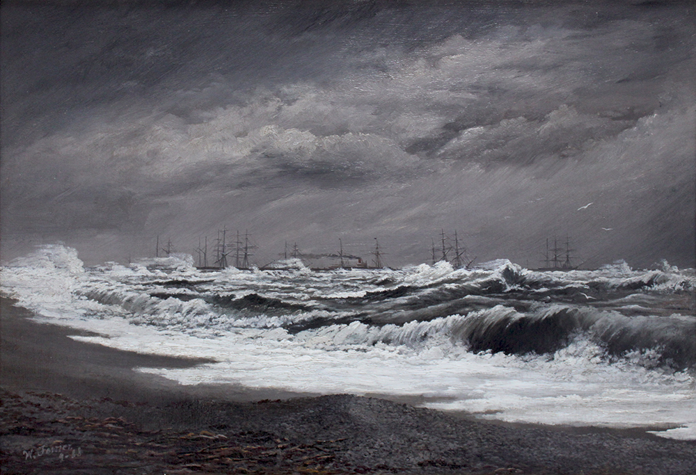
William Ferrier (1855-1922), Breakwater Timaru Running a Southerly Gale, 1888, Oil on canvas, Aigantighe Art Gallery Collection 2002.10
William Ferrier was born in Edinburgh, Scotland and immigrated to New Zealand in 1869. He trained as a photographer in Christchurch and Oamaru, and in 1881, set up his own studio in Timaru. Ferrier was the grandfather of the well-known New Zealand painter, Colin McCahon (1919-87), who was born in Timaru. Ferrier is known for his success in documenting a vital part of Timaru’s history on photographic film, but he was also a painter. His landscape paintings were exhibited with the South Canterbury Art Society, of which he was a founding member. He was also a member of the Otago Art Society and Canterbury Society of Arts. Breakwater Timaru Running a Southerly Gale was produced from one of Ferrier’s photographs (see reproduced above). This seascape, with its crashing waves and stormy skies shows the power of nature, and was a popular theme Ferrier returned to in both photography and painting.

People bathing at the beach in Timaru with the port in the background photograph by William Ferrier 1894-01-06 from the The New Zealand Graphic and Ladies Journal - Auckland Libraries Heritage Collections NZG-18940106-0001-02
A Popular Southern Seaside Resort. Auckland Weekly News, 1 April 1909, p.6. Auckland Libraries Heritage Collections AWNS-19090401-06-01 kura.aucklandlibraries.govt.nz/digital/collection/photos/id/199340/rec/46
Shows a view of sailing ships across the harbour from Caroline Bay, Timaru, August 1885 : Rangitiki 1188 Tons; Wakatipu 1158 Tons; Barque Cingalese 698 Tons; Wareatea 288 Tons; Annie Bow ? 250 Tons; Allegiance 1180 Tons; John Knox 291 Tons; Barque Missina 276 Tons; Ketch Ocean Bird 33 Tons; Barque ??aminer 266 Tons. Cite as: Brodie Collection, La Trobe Picture Collection, State Library of Victoria.. 1885 H99.220/396 Record ID 9917361153607636This work is out of copyright http://handle.slv.vic.gov.au/10381/14570
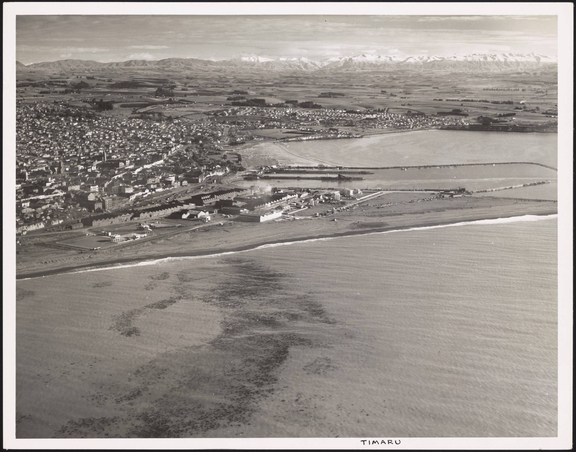
Aerial photograph of Timaru, South beach looking north, Timaru Port, 1940-1949 - Auckland Libraries Heritage Collections NZMS-1803-01123
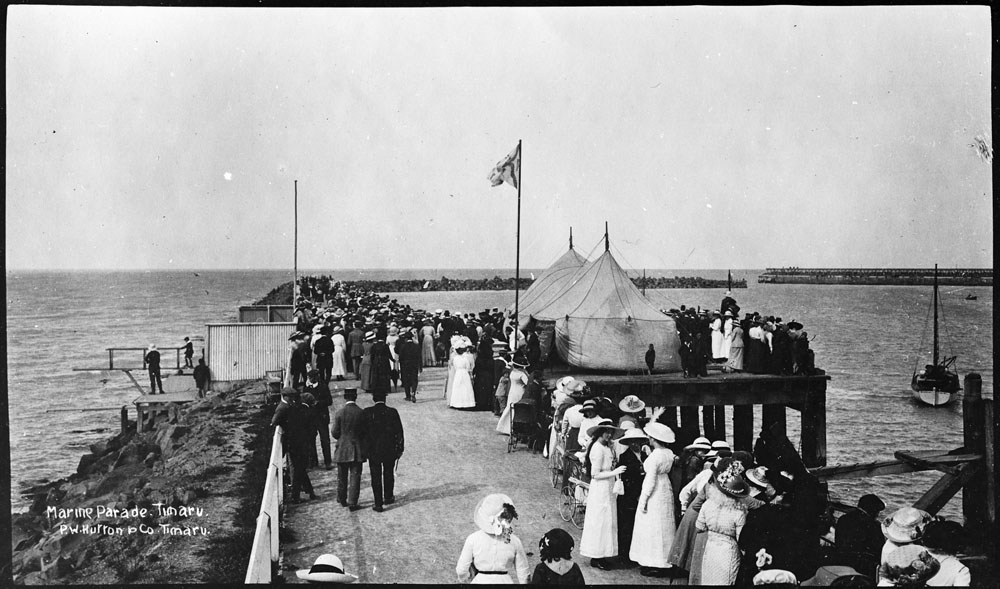
Showing crowd along Marine Parade, Caroline Bay, Timaru. P.W.Hutton and Co. Timaru - Auckland Libraries Heritage Collections 35-R1498
1904 A scewne on the moody wharf, Timaru, showing the lighthouse and signal station on the top of the hill. Auckland Weekly News, 7 July 1904, p.2. Auckland Libraries Heritage Collections AWNS-19040707-02-04
- kura.aucklandlibraries.govt.nz/digital/collection/photos/id/183795/rec/27
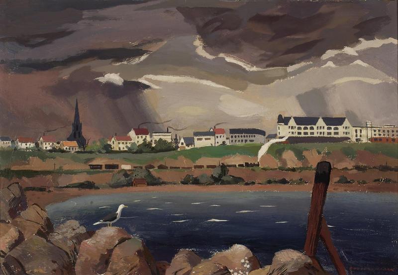
Rusell Clark's oil painting on board from 1930 view from marine parade looking to the Bay Hill with Chalmers Church and the Hydro Grand buildings in the distance. Auckland Art Gallery Toi o Tāmaki, gift of the Friends of the Auckland Art Gallery, with funds from the J B Spring Bequest, 1998
Poster, 'A Map of New Zealand', 1931, United Kingdom, by MacDonald Gill, Dobson, Molle and Co. Ltd., H.M. Stationery Office, Empire Marketing Board. Found in collection, 2012. Te Papa (GH021717)


