The stories that inspired CPlay...
One of the most meaningful types of play is when children engage their imaginations, leading the story while a trusted adult joins in the fun with them. Therefore, it was important for CPlay to ensure that people of all ages, abilities, and sizes could play together and be encouraged to use their imaginations. An added bonus was if their imaginations were sparked by the stories and history of our area. It helps us learn about where we have come from, gain a better understanding of ourselves. A strong sense of self, helps foster self-confidence, resilience, and the ability to make healthy decisions while navigating life's challenges. Here are some of the stories that have inspired the CPlay playground.
Check out our draft of our A3 free guided tour
The stories that inspired CPlay...
One of the most meaningful types of play is when children engage their imaginations, leading the story while a trusted adult joins in the fun with them. Therefore, it was important for CPlay to ensure that people of all ages, abilities, and sizes could play together and be encouraged to use their imaginations.
An added bonus was if their imaginations were sparked by the stories and history of our area. It helps us learn about where we have come from, gain a better understanding of ourselves.
A strong sense of self, helps fosters self-confidence, resilience, and the ability to make healthy decisions while navigating life's challenges.
Here are some of the stories that have inspired the CPlay playground.
Best place to start is at the mouri stone. Place your hand and give you thoughts and feelings to the stone to hold on to.

Haami Rahui who was the Kaikorero (cultural connector) with whakapapa (ancestry) to both Te Runanga o Arowhenua and Te Aitarakihi, blesses the mauri stone - Photo Geoff Cloake

Aoraki/Mount Cook, mountain, the highest in New Zealand, located in the Southern Alps/Ka Tiritiri o te Moana, west-central South Island. It reaches an altitude of 3,724 metres (12,218 feet) – high enough to be permanently covered in snow. - Photo Geoff Cloake
Two creation stories feature waka.
Some say that an ancestral waka Ārai-te-uru sailed past what is now Te Tihi-o-Maru Timaru, down the coast and capsized near Matakaea (Shag Point). The food turned into the Moeraki boulders and the passengers became landmarks of Te Waipounamu (South Island). Aoraki is on his grandfather Kirikirikatata shoulders. Pātītī, Tarahaoa and Hua-te-kerekere (Big and Little Mount Peel) were also passengers.
In another creation story Aoraki and his brothers were forced to climb onto the back of their waka. They were stranded and turned the Southern Alps. The canoe became the South Island, and is known by Māori as Te Waka o Aoraki. This creation story of the landscape surrounding Arowhenua is a central tradition for the Waitaha, Rapuwai, Kāti Hawea, Kāti Mamoe, and Kāi Tahu tribes from which the local hapū Kāti Huirapa carry descent.
Creation stories vary. These examples are just a few among many and should not be considered exhaustive or definitive representations of all creation narratives.

Rock art reproduction on the wall of the shelter at the Caroline Bay Playground in Timaru. - Photo Francine Spencer. It is important to not reproduce this rock art image without permission. Respecting indigenous art is paramount, as it carries the mana (spiritual power and authority) of its creators and communities. Seeking permission for reproduction is essential to honor and uphold the cultural significance of the artwork.

Piece of rock art on display at the Te Ana Māori Rock Art Centre in Timaru. Photograph by Geoff Cloake. Image used with the permission from Te Ana Ngāi Tahu Māori Rock Art Centre and Te Rūnanga o Moeraki. Please do not reproduce this rock art image without permission.

View north up the Timaru District coastline showing an interruption by the Timaru basalt formation. It forms the first hill south of the Canterbury Plains where Timaru's Hilton Highway ends (named after Timaru's first woman Mayor of Timaru City 1959-62). Photography courtesy of Geoff Cloake 2012.
2.5 M years ago lava flowed like fingers from the Waipouri (Mt Horrible) area.
This is the most recent volcanic activity in the South Island. It was formed in a single event from a line of fissures, rather than a cone shaped volcano and is believed to be dormant. The lava flowed down a slope to what is now the coastline. The sea was probably nowhere near the erupting lava but has advanced, eroding the basalt and helping to shape the coastline’s reefs.
Today you can see the lava as an “apron” at the foot of Dashing Rocks. The basalt rocks below the Benvenue Cliffs was quarried and placed to mitigate erosion.
Basalt was used as a construction material and the “bluestone” blocks can be seen in many of Timaru’s heritage buildings, homes, and bridges. The quarried rock was also used to construct Timaru’s artificial harbour, this work began in 1878.
The floor is lava obstacle course is a nod to our volcanic geology.
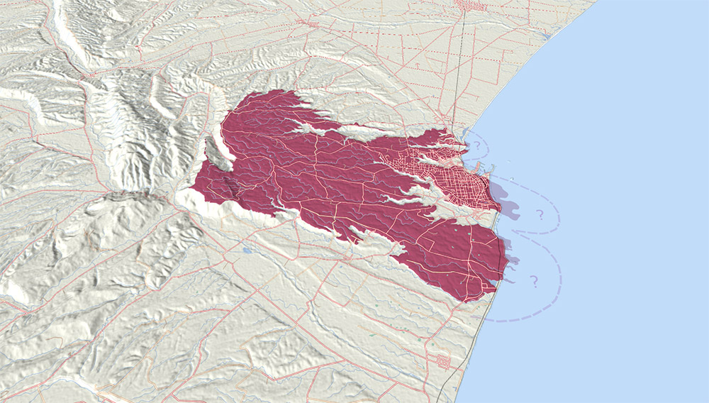
Lava once flowed from somewhere west of Claremont (Wapouri / Mount Horrible) down a gentle sloping plain. The sea was probably nowhere near the erupting lava but has advanced occasionally, eroding the basalt and helping to form the current coastline. Diagram courtesy of Geoff Cloake.

Loess layers at Dashing Rocks - South Canterbury Drone Photography
The glaciers ground rock and the dust blew in to form Timaru’s loess cliffs.
Loess (wind-blown silt from the mountains) was deposited over 9,000-11,000 years ago. This was when the Canterbury Plains were covered in glaciers, in the last ice-age. As the glaciers retreated, they left a layer of gravel and sand.
Winds blew across the plains, picked up the fine sediment and deposited it on the lee side of hills forming loess cliffs. Timaru has some of the thickest and most extensive deposits of its kind in the world. The loess layers change in thickness, grain size, and mineral content depending on the climate at the time and deposited in layers.
In the 1890s amateur Timaru geographer John Hardcastle realised the layers were a time-line of past climates and wrote an important scientific paper on it. It’s still used world wide today, to help us better understand our changing climate, and to predict future change.
The stripes in the light house mound and boulders are a nod to our loess geology.

Mōkihi are among the few human-made objects to be depicted in southern rock art. Mōkihi display at Te Ana Ngāi Tahu Māori Rock Art Centre.
The reefs were abundant in marine life and an important food source for Māori.
Mahika kai (to work the food) is about traditional ways of how food is grown, gathered, and safeguarded.
Māori came to Aotearoa New Zealand from Polynesia in the 1200s. Te Rūnanga o Arowhenua is the principal Māori kainga (settlement) in the Aoraki region, from the Rakaia to the Waitaki and back to the main divide. Their marae is in Te Umu-kaha (Temuka). They are one of 18 Paptipu Rūnanga (main villages) leaders among their southern communities. They primarily claim descent from the hapu Kāti Huirapa and affiliate to the iwi Waitaha, Rapuwai, Kāti Hawea, Kāti Mamoe and Ngāi Tahu.
Trading trails, settlements and events extend into the lakes, rivers, and corridors of native bush which provided rich hunting and gathering grounds. A long established cycle of gathering, traveling, and trading endured until the late 1800s.
The mahika kai, whare, tuna eels are inspired by our local Māori history, stories and culture.

these benches were inspired by traditional Mōkihi rafts, old hardwood that was shipped over from Australia and used in the first breakwater at the Port is being replaced, and some of the timber was donated to CPlay. Lovely connection of waka, Mōkihi, and European shipping.

Engraving showing the Timaru Breakwater 1888. Picturesque atlas of Australasia"; The Picturesque Atlas Publishing Co.

Government Landing Service at the foot of Strathallan Street, Timaru, 1860s. Shows buildings by the waterfront and possibly the shed where the lifeboat was stored. - tiaki.natlib.govt.nz/366331
Mahikakai trails were used on a seasonal rotation, so you were harvesting plants and animals at the time when they were at their best.


Tukutuku Panels by Francine Spencer and Roselyn Fauth -Not to be reproduced without permission
Whalers arrived 1839, and sheep farmers in 1851.
Abel Tasman, is recognized as the first European to discover New Zealand in 1642. Captain James Cook reached New Zealand in 1769, mapped the coast, documented the flora and fauna, met Māori, and opened the door for European exploration and colonisation.
Whalers set up camp here 1839-1840 near Pohatu-koko and nicknamed the stream “Whaler's Creek." This is now piped under the playground and comes out at the bay. The whalers may have named the bay after a whale supply ship "Caroline" that also collected whale oil in the region.
The first European settlers arrived in 1851 to establish a sheep station.
The first immigrant ship to sail direct from the UK to Timaru arrived in 1859 with 120 settlers. There were just five houses here at the time.
By 1866, 1,000 people lived in Timaru. In 2023 the Districts population was 48,400 with 21,090 households.
The crates floating around the wreck are symbolic of the immigrants, their hard work, and early exports.


Timaru Volunteer Rocket Brigade. Photographer William Ferrier c1882. South Canterbury Museum 0844
The challenges of crossing wide rivers made the sea key.
30 Ships wrecked or stranded in Timaru between 1864-1892. The sea could become rough with little wind and sailing ships didn’t have enough wind or sea room to sail to safety, often dragging their anchors and wrecking. The harbourmaster kept a lookout and gave ships instructions by hoisting flags. The 1878 Blackett lighthouse used to be on the cliff above the harbour, before this, they used a watch tower. They could summon rescuers with a signal gun. The Volunteer Rocket Brigade fired a rope to ships, so people could zip-line to shore. Or the Alexandra lifeboat could help.
The locals funded their own harbour to improve safety and efficiency, helping to secure the Timaru and South Canterbury’s economic future. Major industries and exports were wool, grain, flour and frozen meat. South Canterbury was known as the food bowl of NZ in since the early 1900s. Timaru is one of the major cargo ports of the South Island. Fishing, logging, tourism and management of industrial land also contribute to revenue.
These stories inspired the lighthouse, flying fox, double swing and shipwreck.
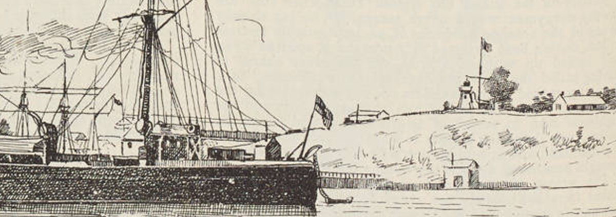
Section of the HMS Ringarooma cruiser in Timaru Harbour, the Blackett Lighthouse up on Le Cren Terrace 1895-02-23 - Auckland Libraries Heritage Collections NZG-18950223-0180-01
What was once a lagoon, is now Ashbury Park. Aerial view of Timaru, showing Caroline Bay, harbour and town between 1920 and 1939. - Auckland Libraries Heritage Collections FDM-0690-G
A changing coastline forms new sandy bay.
The sea used to reach the cliffs at Caroline Bay. After the harbour was constructed and the north mole completed in 1890, sand started to build out from the cliffs and to create a new sandy bay.
The council leased the foreshore from the harbour board in 1902 for a European-style beach resort.
In 1904 the volunteers from the Beautifying Association helped erect a band rotunda, caretaker’s cottage and tearooms. In 1911 Caroline Bay Association was established by volunteers to host Christmas carnivals, attracting thousands. The first swings and seesaw arrived in the 1912, and a new playground built in 1915.
The Soundshell was built in 1936.
A paddling pool and rocking horse were added in the early 1960s.
By 2020 the beach area had extended seaward by 34 hectares.
CPlay volunteers further enhanced play at the bay, by fundraising and organising the 2023 playground, which draws on art, history and culture to fire up local and visitors imaginations.
1911-10-11 - Photo of children playing on the beach and swimming at Timaru. The New Zealand Graphic and Ladies Journal, 11 October 1911, p.30. Auckland Libraries Heritage Collections NZG-19111011-0030-02. https://kura.aucklandlibraries.govt.nz/digital/collection/photos/id/147415/rec/216

Children's playground area on Caroline Bay in Timaru, circa 1970. Photographer L W McGrath. Image courtesy of South Canterbury Museum 2014/008.055

Caroline Bay Playground 2020. Courtesy of Roselyn Fauth.
Can you find these symbols and themes inspired by Timaru's stories, geology, history and culture?

On an ancient pathway, this is Takiroa, Waitaki Valley. Takiroa is a significant landmark in the tradition of Kāi Tahu Whānui.
 This is reproduction of rock art that was removed from Takiroa (Waitaki Valley). It is an example of the 500+ Māori rock art images in South Canterbury and North Otago created by Ancestors of the Arowhenua people in the earliest tribal groups of Rapuwai and Waitaha. The meaning and function have been lost over time, so we are left to interpret the art.
What does this look like to you?
The loess (looks like clay) section and layers eroded surface on Timaru Basalt at Dashing Rocks. - Nature and distribution of loess in Canterbury, New Zealand
 The stripes in our lighthouse mound are a nod to the loess layers. Dust blew over Timaru and created loess cliffs Over 1000s of years. As the climate changed so did the characteristics of the dust, creating distinct layers.
Can you see these layers in the cliffs around the bay?

The basalt at Dashing Rocks flowed here from Wapouri / Mount Horrible. - Photo Roselyn Fauth

Artist Francine Spencer with taniwha that she designed and gifted to CPlay. - Photo Roselyn Fauth
 Cplays’ taniwha design is by artist Francine Spencer, Ko Taranaki, Kati Mamoe, Waitaha, Rapuwai, Ngai Tahu ngā Iwi. Taniwha feature in Māori creation stories and are often associated with rivers, lakes, or oceans. They can be guardians, ancestral spirits, even dangerous spiritual creatures capable of causing harm.
Can you imagine what the taniwha could do when you fly over it?
 Cplays’ flower symbolizes Pasifika hospitality and the deep connection across the ocean, as reflected in the migration of tuna (eels) who swim from NZ to the Tongan Trench to spawn. The Frangipani is used in lei, kahoa, salusalu (flower garland) known as the kakala (lei making) process. The lei is gifted to welcome, show love and kindness to the person receiving the gift.
Can you pretend you are on a journey to the pacific islands?


Chris Sargent, right, and South Canterbury Museum director Philip Howe with the moa bones and footprints that Sargent found at Paeora beach 2022. - Photo Stuff Timaru Herald
 This is a reproduction of an actual moa foot print found at Pareora beach. South Canterbury was the home to the extinct giant moa. The discovered footprints were 3D scanned by the South Canterbury and Canterbury museum. CPlay made 3D moulds to push into the concrete paths.
Can you compare your foot with an extinct moas?

Photo by Geoff Cloake of the Southern Lights from Timaru Aoril 2023.

A moon phase diagram demonstrates early Māori peoples detailed knowledge of astronomy and connection to the planting and harvesting of crops, influenced by Te Maramataka, the Māori lunar calendar. - otagomuseum.nz/puaka-and-matariki
 Seafarers used the Southern Cross to help navigate. Some Māori saw it as an anchor, while European’s saw a cross. CPlay integrated the stars to help people learn how to find celestial south. The moon's phases are inspired by maramataka, a traditional Māori calendar that recognizes the link between humans and nature. This includes understanding subtle changes in time and seasons for planting and fishing.
Can you make the stars and moon phases spin around you?
Sketch of double-hulled waka. Ministry for Culture and Heritage nzhistory.govt.nz/media/photo/sketch-double-hulled-waka,
 Cplay viewed the waka as a symbol of ancestors' ties to the sea, navigation skills, and connections to mahika kai stories. Waka (Māori canoes) were used for transportation, fishing, and intertribal warfare. They could be made from a single hollowed-out tree, and capable of carrying many people and supplies on rivers, lagoons and oceans.Cplay viewed the waka as a symbol of ancestors' ties to the sea, navigation skills, and connections to mahika kai stories. Waka (Māori canoes) were used for transportation, fishing, and intertribal warfare. They could be made from a single hollowed-out tree, and capable of carrying many people and supplies on rivers, lagoons and oceans.
Can you pretend to use your waka to find tuna (eels), shark and flounder?
Rangatata Traffic Bridge. From the album: Scenes of New Zealand, circa 1880, Timaru, by Messrs. F. Bradley & Co. Te Papa (O.042416)

 South Canterbury’s boundaries are the large, snow-fed rivers Waitaki and Rangitata. Māori used Mōkihi rafts made of flax or raupō to cross rivers. Imagine how challenging it must have been to cross these rivers before we had ferry's and bridges. The Rangitātā River was bridged at Arundel 1872. The Waitaki was bridged at Glenavy 1877. South Canterbury’s boundaries are the large, snow-fed rivers Waitaki and Rangitata. Māori used Mōkihi rafts made of flax or raupō to cross rivers. Imagine how challenging it must have been to cross these rivers before we had ferry's and bridges. The Rangitātā River was bridged at Arundel 1872. The Waitaki was bridged at Glenavy 1877.
Fun Fact: In 1873 the Duke of Edinburgh wrecked in Timaru, it was carrying timber from Auckland for the Temuka bridge. It was refloated and re-named the Euphrosyne and disappeared while sailing from Dunedin for Oamaru in 1875.


LEFT An early map of Timaru in 1860. RIGHT zoomed in area showing the labeled area "Pohatu Koko" next to the "old whaling station". This is where the traffic lights are at the end of Wai-iti Rd, and Evans St. The stream running through the area can be seen above. This stream is now piped under the viaduct at the bottom of Wai-iti Rd, under the playground and out sea at the Benvenue end of the boardwalk.
Courtesy of the National Library. Archives New Zealand/Te Rua Mahara o te Kāwanatanga. Christchurch Office. Archives reference: CH1031, BM 245 pt 2, R22668176


In this map you can see the Waimataitai Lagoon before it was drained and turned into a park. The stream was piped underground and can be seen at the golf course. Miscellaneous Plans - Borough of Timaru, South Canterbury, 1911 - T.N. Brodrick, Chief Surveyor Canterbury ndhadeliver.natlib.govt.nz/IE31423732
What was once a lagoon, is now Ashbury Park. Aerial view of Timaru, showing Caroline Bay, harbour and town between 1920 and 1939. - Auckland Libraries Heritage Collections FDM-0690-G

Tuna / eels in the steam that runs beside the holiday park. This stream connects to a underground drain under Ashbury Park, Waimataitai Beach. Photo Supplied by Timaru Top 10 Holiday Park

Whales Creek Railway Viaduct at the foot of Wai-iti Rd and Evans Street, Timaru, New Zealand, 1904-1915, Timaru, by Muir & Moodie. Purchased 1998 with New Zealand Lottery Grants Board funds. Te Papa (PS.001051)


LEFT A try pot used at the Weller Bros Whaling Station near this place 1839-1840. The Wellers’ workers caught whales and rendered the blubber down into oil in try pots for two seasons. RIGHT Looking up towards the viaduct near the Evans St and Wai-iti Rd intersection where the stream runs underground. Photo Roselyn Fauth

An early map and detail of Timaru in 1860. - National Library. Archives New Zealand/Te Rua Mahara o te Kāwanatanga: CH1031, BM 245 pt 2, R22668176

Ship deck can be accessed by a ramp on a mound, so everyone can have fun steering the ship, ringing the bell and using the talker to give orders to the ship crew. Photo: Roselyn Fauth
 Europeans and Americans arrived to hunt whales, leading to the establishment of whaling stations across NZ. The Sydney-based Weller brothers set up a short-lived whaling station in Timaru in 1839. The first recorded whale oil shipment from Timaru was "70 tun". A tun of oil was 8 barrels by volume, (a wine tun was 252 gallons). Some say Caroline Bay was named after a whale supply ship, hence the stencil on this barrel.
The Tiriti o Waitangi (The Treaty of Waitangi) was signed in 1840.
Fun Fact: The first European to be born in Timaru was the son of a former Timaru whaler and his cradle was a gin crate.

One of Timaru's earliest shipwrecks occurred on Thursday (DECEMBER 1866) evening with the complete wreck of the schooner Prince Consort, a 35-ton vessel captained by Ritchie. Having arrived from Lyttelton and discharged her cargo, the schooner awaited further instructions. On Thursday, amid strong north-east winds and high surf, the Prince Consort drifted closer to shore, eventually being struck by a wave that capsized the vessel. Despite efforts to anchor securely, the ballast shifted, causing the ship to remain on its beam ends. Three men were on board, one was washed away but clung to a spar, while two remained on the vessel until rescued by the lifeboat "Alexandra," manned by Mr. Mills and his crew. The washed-away man was heroically rescued by Mr. Bertrand of the Custom House. Although the crew survived, they lost all personal belongings, and the ship was deemed a total loss, insured by the New Zealand Insurance Office. - https://paperspast.natlib.govt.nz/newspapers/THD18661222.2.10

LEFT The home of George and Elizabeth Rhodes, the first European house in Timaru. RIGHT A branding iron used at the Levels run to brand sheep and wool bales photo taken of it in display at the SC Museum. In 1850s is was compulsory to brand sheep and to build sheep dipping facilities. This is where the area Washdyke gets its European name. - South Canterbury Museum
 The first Europeans to settle in Timaru established the Levels sheep station, this is their branding iron. Their first export was 20 bales of wool in 1853. James McKenzie was accused of stealing 1000 sheep from them in 1855. He escaped jail twice before being pardoned. The Mackenzie District was named after him.
Fun Fact: 1859 120 British settlers arrived to Timaru on the Strathallan, the journey took 60 days. A lady wrote in her diary, that if Timaru was a third of the size of London she would be happy. When she arrived there were only five houses!

View of Timaru Harbour 1877. View looking north along the waterfront, with sailing ships, men beaching a boat, and a large building, probably Belford Steam Flour Mill near the waterfront, alongside other wharf or factory buildings. From a sketch books held by Hocken Library. By Fanny Wright Brunton - https://tiaki.natlib.govt.nz/#details=ecatalogue.59362

C1877 The Roadstead, Timaru, N.Z. Engraving of Timaru from the original edition of the Illustrated Australian News.Courtesy of Fauth Private Collection. - Illustrated Australian News (Melbourne, Vic. : 1876 - 1889) Wed 3 Oct 1877. Page 155 TIMARU, CANTERBURY, NEW ZEALAND..

Engraving showing the Timaru Breakwater 1888. Picturesque atlas of Australasia"; The Picturesque Atlas Publishing Co.
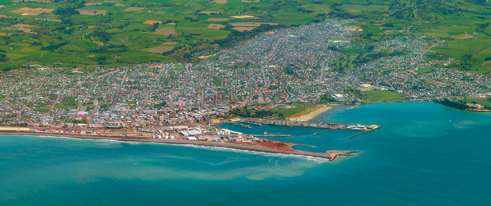
View of the Port from the sky in 2014. Photograph by Geoff Cloake.

Alexandra lifeboat in storage - Photo Roselyn Fauth

 This barrel acknowledges Timaru’s first shipwreck, The Prince Consort which dragged its anchors in a big sea and gale. It’s ballast shifted and broke up in the night. A swimmer rescued a man who had washed overboard. And the crew of the 1864 Alexandra life-boat rescued two more. The lifeboat was also used to save 40+ men in the 1882 Benvenue diaster.
Can you pretend to evacuate with your crew from the sinking ship?
City of Perth and the wreck of the Benvenue at Caroline Bay 1882. - Engraving published in Illustrated Australian news
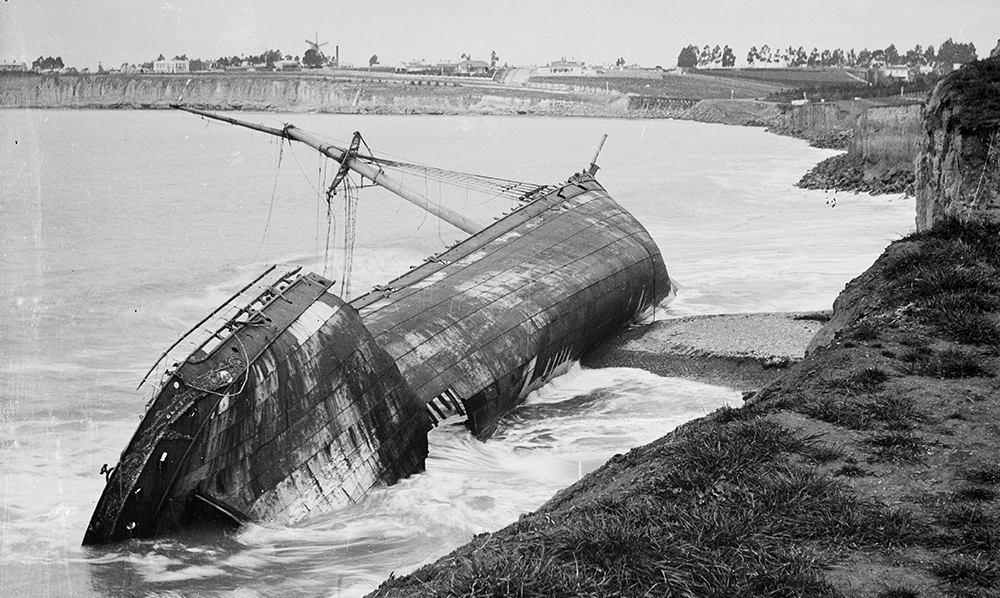
Section from a photograph taken by the Burton Brothers circa 1882; of the "Ben Venue" stranded. In the distance you can see the Caroline Bay coastline before the sand started to accumulate. Courtesy Te Papa (C.025205)

Benvenue Monument, Sophia Street, Timaru - Photograph Roselyn Fauth 2024

This memorial, paid for by public subscription, was constructed as a token of gratitude to those involved in an endeavor to rescue the crew of two ships, the Benvenue and the City of Perth that foundered off the coast of Timaru on 14 May 1882. Located at the northern corner of the triangle between Perth Street, Sophia Street, and King George Place.
"Benvenue"
Master - Captain W.H. McGowan
Iron Sailing Ship
999 tons
Total Loss
"City of Perth"
Master - Captain C. McDonald
Iron Sailing Ship
1189 tons
Refloated
This tablet contains the names of those who perished in the endeavour to save life 14th May 1882.
Alexander Mills Harbour Master Timaru
John Blacklock First Mate "City of Perth"
Robert Gardiner Second Mate "City of Perth"
Donald McLean Carpenter "City of Perth"
William McLern Waterman Timaru
Emanuel Nielson Boatman Timaru
Martin Beach Boatman Timaru
Harry McDonald Boatman Timaru
George Falgar Boatman Timaru

Timaru Herald, 27 May 1882, Page 2
The Dunedin Echo, referring to the late wrecks at Timaru, says : " One lesson we may draw from the catastrophe. Heroism is found amongst the workers. One has not to go to wars or battles to find true heroes. The men who risked and those who lost their lives at Timaru were true heroes. At the shrine of duty they sacrificed themselves, and we hope some effort will be made on behalf of those they have left behind them to show that the people of the colony know how to value ouch services as they performed. Captain Mills, exhausted by anxiety and work, brought ashore to die, surely shows what a brave man will do in the performance of his duty. He showed that true courage can be manifested in doing Harbor Master's duty. Yes; truer courage than is shown by many military leader. We hope, we repeat, that if these brave men have left behind them some who will miss the bread-winners, that they will not be allowed to feel their loss. As for the Timaru roadstead, no doubt these losses will be of immense injury to it but we hope to see the residents pushing on their Breakwater, and even using these sad accidents as additional spurs to their exertions to complete the Breakwater."

This photograph shows the Ben Venue wreck in the distance wrecked on the basalt rock apron below the cliff c1880s. Curtosey of Te Papa; Timaru, 1880s, Timaru, by Burton Brothers studio. Purchased 1991. Te Papa (O.034179)
In bright sunshine, and in an almost calm atmosphere, It caused the greatest emotional upset in the history of the town, and waves of sympathy far beyond the borders of South Canterbury. - https://aorakiheritage.recollect.co.nz/
The shipping disasters and loss of life at Timaru, which occurred on Sunday 14th May, 1882.. Aoraki Heritage Collection, accessed 21/05/2023, https://aorakiheritage.recollect.co.nz/nodes/view/239


The large painting (about four feet in length) of the wreck of 'City of Perth' and 'Ben Venue' at Timaru hung for many years in the Farmers tearooms and now the painting is at the Port Company Offices, Timaru located along Marine Parade which is located near the distal end of the Port Loop Road a route to Caroline Bay and the harbour. The plate below the painting reads "Wreck of the Ben Venue and City of Perth on 14 May 1882, Presented to: The Port of Timaru Ltd. by Arthur Bradley. Last surviving son of Issac Bradley, A member of the rescue craft's crew." Photo by Roselyn Fauth with permission of PrimePort Timaru.
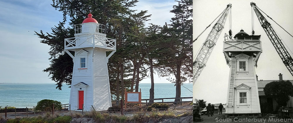
The Blackett Lighthouse was originally on the Terrace, No. 7. It was later relocated to the corner of Te Weka Street and Benvenue Ave, and then again to the Benvenue Cliffs. It is a Category II structure and the Historic Places Trust. LEFT: The Lighthouse at its current site in 2021. Courtesy of Roselyn Fauth. RIGHT: Timaru's lighthouse being relocated 1980. Courtesy of South Canterbury Museum 2014/107.73
Panels feature lighthouse keeper implements so you can pretend you are collecting your tools to maintain the lens, light the lamp etc... The flags were hoisted by the Harbour master to instruct ships anchored in the bay. You could pretend to go up the lighthouse to check on the sea conditions and then fly flags to instruct ships to go out to sea to prevent loosing anchors and wrecking on the shore.

Keepers weren’t just there to tend to the lens only. They also had to maintain other buildings around the light station and keep things running smoothly. Courtesy RG26: ZZ, Standard Apparatus Plans; Vol. 19, Plate 98. Light Keeper’s Implements, 1862.

 The Volunteer Rocket Brigade rushed to the rescue with two rocket guns, they fired lines to ships so crews could zip-line to shore. This brigade was disbanded when the breakwater was completed.
Can you create your own disaster scenario using the mouse wheel?


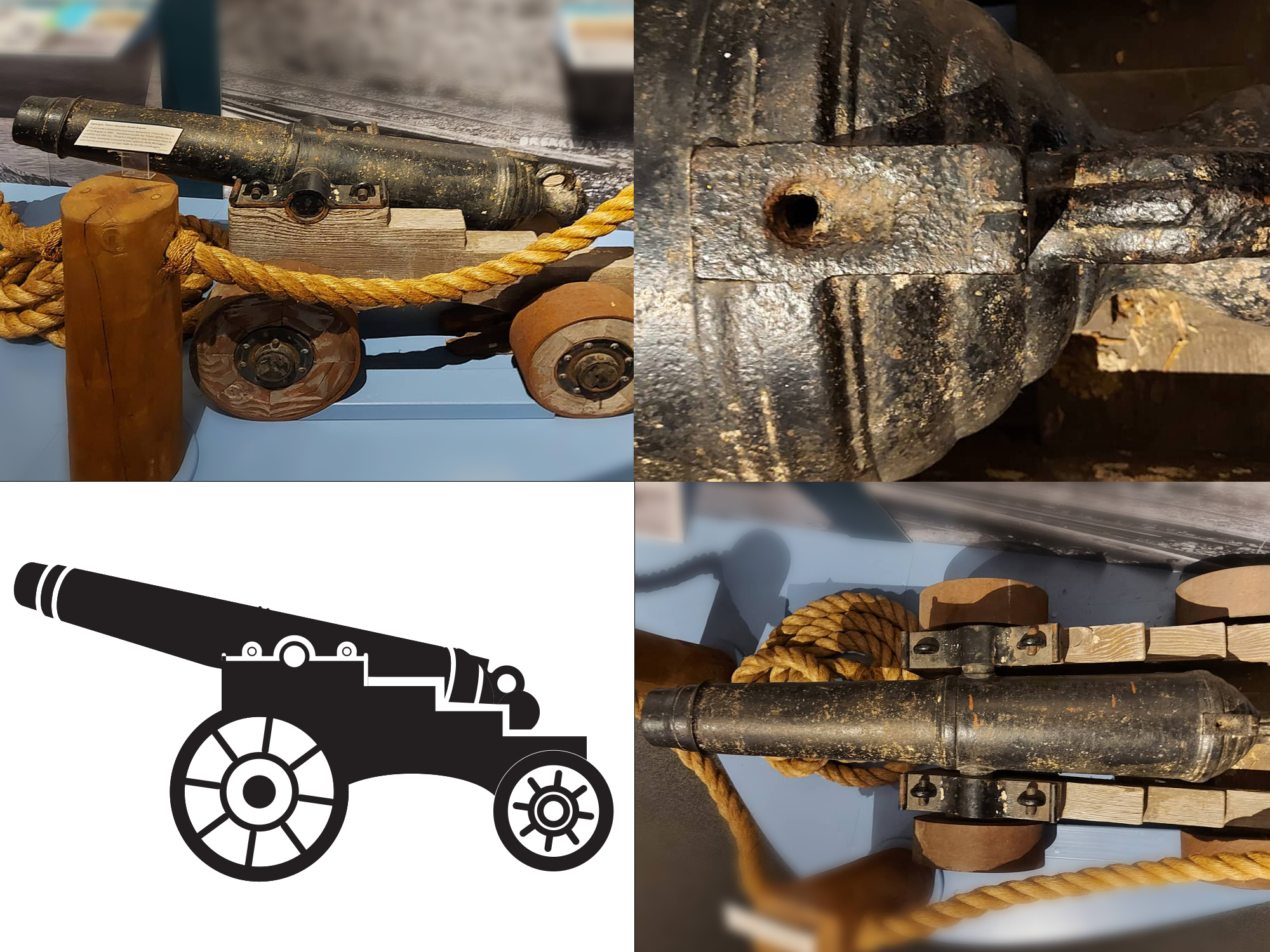
This gunnade is believed to have been delivered to Timaru for the use of the Brigade in 1882. Positioned outside the Timaru lighthouse, it probably saw little use. The gun is through to ave remained there for many years. Eventually it passed to the local collector, Keith McFadgen, who had the present gun carriage made to rest the cannon upon. - On display at the South Canterbury Musuem - Photography by Roselyn Fauth

Timaru Volunteer Rocket Brigade. Photographer William Ferrier c1882. South Canterbury Museum 0844

Siblings Ruben Cloake and Annelies Bray have a race on the 50m tandem flying fox. Photo: Geoff Cloake
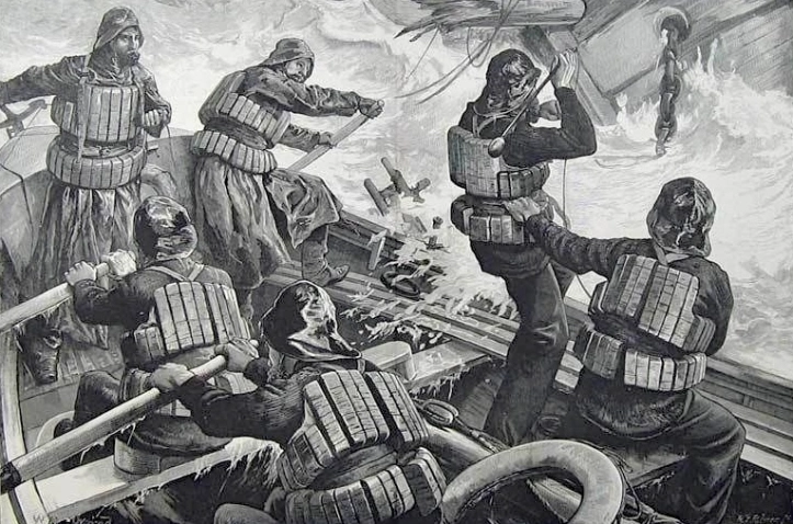
How the Illustrated London News saw rowing lifeboats in action. heartheboatsing.com/for-those-in-peril-on-the-sea/

Alice Solace, Rebecca Jackson, Sharleyne Diamond and and friends enjoy the new Playground Center Cyclops swing - Photo Supplied

A lifeboat crew rowing to rescue shipwrecked sailors. published 1893-02-11 The New Zealand Graphic and Ladies Journal, 11 February 1893, p.121 - New Zealand Graphic; Wright, Henry Charles Seppings, 1849-1937 - Auckland Libraries Heritage Collections NZG-18930211-0121-01
How the Illustrated London News saw rowing lifeboats in action. heartheboatsing.com/for-those-in-peril-on-the-sea/
https://www.ngataonga.org.nz/search-use-collection/search/F7142/

Section from a photograph taken by the Burton Brothers circa 1882; of the "Ben Venue" stranded. In the distance you can see the Caroline Bay coastline before the sand started to accumulate. Te Papa (C.025205)
 Stowaways on our shipwreck! NZ’s birds and bats have declined rapidly due to stowaways and introduced pests like rats, mice, stoats, cats, deer, goats, pigs, and wasps.
Fun Fact: Sculptor Donald Patterson made these two rat sculptures. He also made the Landing Service’s Captain Cain sculpture.

No shipwreck would be complete without some stowaways. The CPlay team commissioned sculptor Don Patterson to create some nasty ratbags in the new playground. - Photo Roselyn Fauth
 Cats were kept on ships to control the rats and mice who damaged food and ropes. There are many centuries-old, maritime stories about ship cats' loyalty, bravery, and companionship.
What do you think this cat is up to? Maybe looking for birds! How many different types of footprints can you find?


Medinella Fauth and Annabelle Fauth on the dolphin at the Caroline Playground, the rats lurk inside the ship. - Photo Geoff Cloake
Changing South: Timaru’s Caroline Bay – remembering a stormy history
Timaru’s Caroline Bay used to be known as the Riviera of the South. A wide, sandy beach, it was where Cantabrians would flock (by train) to swim, sunbathe and attend carnivals and concerts. Though it doesn’t quite draw the crowds of ‘Riviera’ times these days, it’s still a beautiful bay, enjoyed by Timaru locals.
But it wasn’t always a place of peace, nor of fine golden sand. Rather, Caroline Bay was a place of heaving southerly swells and many a shipwreck. According to Timaru researcher Roselyn Fauth, the story is a good one – and she’s helping plan a new playground to pay tribute to it.
“The natural basin of the area provided some shelter for ships,” says Roselyn referring back to the 1800s. “So they could come here, and they could import and export.”
When a big southerly swell roared to life, though, Caroline Bay became a graveyard for ships.
“I think over about 16 years we saw 28 shipwrecks here,” says Roselyn, a Timaru local and passionate historian. Mooring became a point of contention: to move the ships closer for more efficient handling of goods? Or to keep them further out, at a safer distance?
At the centre of all this, caught in the politics, was Captain Mills, who’d been harbour master for 16 years. He had a big job, especially when the sea rose up. Captain Mills bore the responsibility of the lives of all those aboard the ships, as well as the rescue Rocket Brigade and lifeboat crew.
The Rocket Brigade had their work cut out for them. They were the late-1800s version of lifeguards, except arguably (as the name suggests) with a more exciting job – one which involved rockets and “rescue pants”. As Keely Kroening, Museum Educator at South Canterbury Museum explains, when a ship was in trouble the signal gun would be heard all over town, and everyone would come running.
“Then they would send a rocket out, holding a rope over the ship, so that the seamen on the ship could grab the rope,” Keely explains. The seamen would tie off the rope to the mast and the brigade would then send out a pair of canvas shorts attached to a buoy. The seamen would hop inside the rescue shorts and be pulled back to shore, one by one.
In 1878, the people decided enough was enough, and work began on a southern breakwater to help protect the ships from the sea. Not everyone was behind the plan. The government’s marine engineer, John Blackett, wrote a report saying the port was a terrible idea, and that it would change the way sediment flowed up the coast.
He would prove to be right about the sediment: where Caroline Bay was once a rocky cliff, it is now a sandy bay. It also starved the lagoon, of which only about 10 percent remains today. But his opinion didn’t stand a chance against the hundreds of locals who turned up to parade and protest against him on the main street. “They hissed and carried this effigy of Blackett down to the breakwater, filled him with fireworks and then blew him up,” says Roselyn.
The breakwater went ahead, but because steamships took priority on the new moorings, many sailboats were still left to anchor too close to shore. Two years after the port construction, Caroline Bay witnessed its biggest shipwreck yet. It was May 14, 1882, and a huge swell had kicked up. The Ben Venue lost anchor, smashing into the rocks where a crowd from town had gathered.
The crew managed to escape to the safety of the City of Perth, but this lost anchor, too, and drifted down the bay before smashing into the wreck of the Ben Venue. Tragically, nine lost their lives, including Timaru’s beloved Captain Mills.
The story of Caroline Bay is a colourful and tragic one. Roselyn Fauth wants to see it be better celebrated, and that the bay be restored to its earlier glory as a place of play. To replace the tired playground that currently sits where so many once ventured for leisure, work is underway on a new playground inspired by Timaru’s stormy history.
Under the name of C-Play, the new playground features a lighthouse, a buried Ben Venue, a Rocket Brigade-themed flying fox and a big focus on inclusivity. Might this new playground put Caroline Bay back on the map as the Riviera of the South?
Accreditations: South Canterbury Museum, Aigantighe Art Gallery, Te Papa, National Library, State Library Victoria, National Library of Australia, Auckland Libraries Heritage Collections


